History of Braamfontein Pt.2 (Lost Braamfontein)

Some housekeeping: Please follow me on Instagram at @johannesburg1912 where I post interesting Johannesburg related stuff on weekends (mainly).

Follow this blog via e-mail HERE. Scroll down on the right after archives.

My first book ‘Johannesburg Then & Now’ is available at local bookstores or internationally via Amazon or kindle. Click HERE for the relevant links

I’ve come across yet another suburb name that a part of Braamfontein was once known as: Argyle (or Argyll). This was once known as Johannesburg’s smallest suburb and was a few blocks west of the old Johannesburg Hospital. According to Anna Smith’s ‘History of Johannesburg street names’, the Transvaal Volksraad granted Commandant Daniel Egnatius Schutte land on Raandjeslaagte in 1893. He acquired more land in the vicinity of the general hospital, De Korte and Simmonds Streets between 1894 & 1898. As such, the area was also known as Schutte’s or Schutte’s Ground.

Tourist Map from the 1940s showing Argyll

Tourist Map from the 1940s showing Argyle next to Wanderers View

In June 1903 Messrs. Arthur Barnett & Co took over the lease and laid out the small suburb and 31 stands were sold on 26 May 1903. The name Argyll commemorates the fact that the Argyllshire Highlanders camped on Schutte’s ground for several months in 1902.

Photo from the 1940s showing Argyle

Photo from the 1940s showing Argyle

In the first part of this History of Braamfontein series I mentioned, under the section on ‘Clifton’, that land was donated to the government and churches and a post office were built on it. I posted pictures of the Clifton Methodist Church which was demolished in 1973.

Here is information and pictures on the Dutch Reform Church and the post office as well as other ‘Lost’ Braamfontein buildings and houses.

Old map showing the position of some of the buildings in this post

Old map showing the position of some of the buildings in this post

Braamfontein Post Office

This is one of three similar post offices designed by Sytze Weirda’s Public Works Department (the other two were in Jeppe and Fordsburg with Jeppe being the only one still standing). Weirda was Chief of Public Works for ZAR and designed the Rissik Street post office, Plein Street Telephone Tower as well as other government buildings in Johannesburg and Pretoria. The Braamfontein post office (which was identical to the one still standing in Jeppe) was built in 1898 and opened in September of that year on the corner of Biccard and De Korte Street. According to Anna Smith’s ‘Johannesburg Firsts’, it was the first suburban post office to be built. It was demolished in 1966 to make way for a bigger and more modern post office building.

Braamfontein Post Office with the Ductch Reform Church in the background

Braamfontein Post Office with the Dutch Reform Church in the background

New post office today. Church would have been further up near the taller building on the left,

New post office today. Church would have been further up near the taller building on the left,

It was in Clive Chipkin’s book ‘Johannesburg Style’ where I first read about Weirda’s three post offices. Fordsburg was not mentioned but I can confirm that plans exist for a post office in Main Road Fordsburg on stand #90. There is no original building date but there are listings for alterations and additions from 1908. The architect is listed as ‘C.J. Gyde – Public Works Department’ of which Weirda was the head. From the only picture I’ve found, one can see the style is in-line with the other two although for some reason, Fordsburg is not identical to the other two.

Jeppestown Post Office early 1900s

Jeppestown Post Office early 1900s. Identical to Braamfontein

Fordsburg Post Office

Fordsburg Post Office

Dutch Reform Church
This church, bounded by Jorrisen, De Korte and Harrison Streets, dates back to 1897. A year later, a parsonage was added for the Rev. A. Martens which was erected on the Harrison Street side. This addition was designed by Reid & Green. The old church was demolished in 1955 and replaced by a modern church building, which itself was demolished in the 1970s or 1980s

Dutch Reform Church Rectory plans 1898

Dutch Reform Church Parish plans 1898

View of parish from De Korte Street

View of parish from Harrison Street

Braamfontein Dutch Refrom Church from 1905

Braamfontein Dutch Reform Church from 1905

Pirate Bottle Store
Just a few blocks down from the Methodist Church stood the Pirate Bottle Store on the corner of De Korte & Biccard Street. It was owned by liquor merchants Jooste & Bryant whose original building still stands in Jeppe (and is the only building left in Johannesburg with the iron lettering still on the roof). It was built in 1894 and designed by Charles R. Snell. In 1897 and an additional warehouse/shed was added by Snell & Waterson. The store with its iron lettering on the roof can be seen vaguely in the picture below.

Pirate Bottle store is in the middle of the picture. Look for iron lettering on the roof

Pirate Bottle store is in the middle of the picture. Look for iron lettering on the roof

Pirate Bottle Store plans

Pirate Bottle Store plans

Freeman Cottage and shops
This was across the road from the Milner Park Hotel, or Kitcheners, as it’s known today. It was a cottage/shop designed by H.A. Goodman for Mr. Freeman and dates back to 1894. It was common for shop owners to live on the premises.

shops

Freeman shop plans from 1894

Clifton Hotel
This hotel was diagonally across the road from Kitcheners and built in 1899 for owners Bisschop, Mesdas & Co. There were many similarly designed hotels in the area of which Kitcheners and the Devonshire Hotel (further down) are good examples.

Clifton Hotel plans

Clifton Hotel plans

South African Hotel
This is another example of a typical hotel which was on the corner of Wessels and Juta street across from the Braamfontein Cemetery. Braamfontein lost Graaf & Wessels Streets to the M1 highway in the late 1960s.

South African Hotel on the corner of Wessels and Juta Str

South African Hotel on the corner of Wessels and Juta Street

View down Juta street with the hotel on the left

View down Juta street with the hotel on the left

Devonshire Hotel
Official sites date this hotel to the 1930s but one can see from the early pictures that it was more likely to have been built around late 1890s – early 1900s as it is in the same style and structure of other hotels in the area with verified dates. The original building no longer exists.
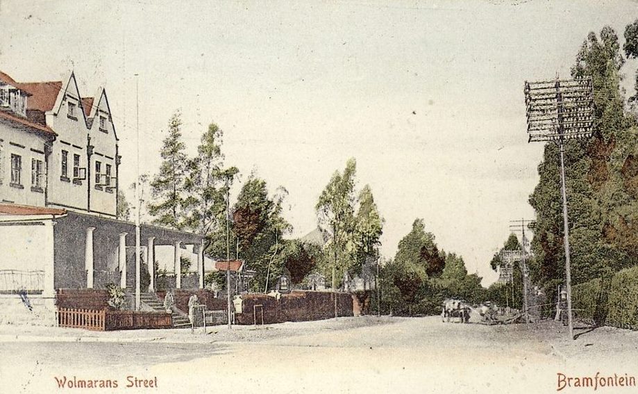
Deveonshire Hotel 1932

Devonshire Hotel 1932

Devonshire Hotel in the 1960s

Devonshire Hotel in the 1960s

Devonshire today

Devonshire today

Sacke Residence
The residence for S. Sacke on the corner of Wolmarans and Loveday Street designed by Harry Clayton in 1892. In 1939, on the same stand, a block of residential flats was built for owners Leeds Buildings LTD. Today, it’s an open piece of land with the flats having been demolished at some point.

Plans for the Sacke Residence 1892

Plans for the Sacke Residence 1892

Geldenhuys Building
On the corner of Wolmarans and Harrison Street is 1896 Geldenhuys Building which is now known as Akhalwayas 2005 Building. The bottom floor used to be occupied by Corbett Bros Family Grocers. The top floor were presumably flats. The pictures below show a then-and-now comparison. Note how the ornate 1st-floor veranda is no longer there. The Sacke residence mentioned above would have been to the left.

Geldenhuys Building looking down Harrison Str early 1900s

Geldenhuys Building looking down Harrison Street early 1900s

Same view down Harrison Str 2010

Same view down Harrison Street 2010

Geldenhuys Building 2014 with the open lot behind it

Geldenhuys Building 2014 with the open lot behind it where Sacke Residence once stood

Masonic Temple
On one of three corners of Juta and Harrison Street stood a Masonic Temple (one corner was the Clifton Methodist Church. Two of the corners are now just street-level car parks and the other across the road from Damelin is a Parkade). It was built in 1906 for the Trustees of Scotia Lodge No.973 and designed by May & Christie.
There are two lodges I found attributed to Braamfontein: Scotia Masonic Hall is listed as being in Braamfontein and was one of the meeting places of Richmond Lodge (1904). Clifton Lodge met at Clifton (?) in Braamfontein amongst others like the Masonic Temple in Plein Street and the Freemason’s Hall in Parktown. Perhaps Clifton & Scotia Masonic Hall was the same temple used by both lodges. I’ve yet to find any pictures of this building but the plans below will give some indication as to what it looked like

Braamfontein Masonic Lodge views

Braamfontein Masonic Hall views

Plans for the Braamfontein Masonic Hall

Plans for the Braamfontein Masonic Hall

Synagogue on Smit Street

Below are plans for the synagogue for the Braamfontein Hebrew Congregation on the corner of Smit and Loveday Streets. I’ve not come across any other information on this building but will update when I do. According to the plans it was designed by S. Isaacs and dated 1919.

Plans for the proposed Braamfontein Synagogue 19191

Plans for the proposed Braamfontein Synagogue 1919

Buildings and houses lost to the Civic Centre

In 1950 it was established that a Civic Centre was needed. Further planning was deferred until 1953 due to a lack of funds. In 1954 the council started negotiating with the home and property owners on the land earmarked for development. This was completed by June 1960. Demolitions, road closures and site clearance followed. A design competition was held and the winning design was picked in 1962. By 1967, excavations for the underground parking and basement levels were on track. Contracts for the two blocks were awarded (around some further financial constraints) and the Civic Centre was completed in 1971. The one-way system around the Centre (which still exists today) came under some criticism. It was explained that the purpose was to ensure that officials arriving to work late didn’t collide with those leaving early… a light-hearted observation I’d imagine.

Map showing the area where houses were demolished for the Civic complex

Map showing the area where houses were demolished for the Civic Complex

Civic Centre looking North

Civic Centre looking south 2014

Civic Theatre from the side looking west 2014

Civic Theatre from the side looking west 2014

Map from 1960 showing what is to be demolished for the Civic Centre and theatre

Map from 1960 looking south showing what is to be demolished for the Civic Centre and Theatre

Below is an interesting picture of Braamfontein taken from the air looking north toward Parktown. I estimate it was taken around the mid-1950s based on the Dutch Reform Church not being there. It shows a good view of the suburb before the Civic Centre and Theatre complex. Only a handful of the buildings in the photo below exist today *CLICK for full image*

Braamfontein looking north from mid 1950s

Braamfontein looking north toward Parktown from mid-1950s. Roughly mirrors the map further up.

Spes Bona School

This school was built in 1905 and designed by the Public Works Department. It was originally known as Hospital Hill School. Around 1909 it became the Spes Bona School and presumably stayed a school until it was demolished to make way for the Civic Centre. It was bounded by Stiemens, Jorrisen, Rissik and Joubert Streets.

Original plans for the Spes Bona School (orginally Hospital Hill School)

Original plans for the Spes Bona School (originally Hospital Hill School)

All Saints Clifton Parish Hall
This was a church built in 1906 and designed by Thomas Anderson Moodie. In 1933 an organ was added as per the plans below. Note on the plans how ‘Clifton’ has been crossed out and replaced by Johannesburg. Alexander Forest was the architect of the organ chamber addition.

All Saints Parish Hall

All Saints Parish Hall

Plans for the organ room addition from 1933

Plans for the organ room addition from 1933

All Saints Parish Church in the 1950s

All Saints Parish Church in the 1950s

Congregational Church
This church was built in 1897 on Loveday Street. It was designed by Howden and Chandler. The plot of land on the corner of Loveday and Stiemens was developed in 1909 for one of the Reverends but there also appears to be plans for a proposed church on that site. I’m not sure if it was ever built, as the 1909 plans show the stand with the house and the church next door and the 1897 plans show the stand as vacant.

Braamfontein Congregational Church Loveday Street

Braamfontein Congregational Church Loveday Street

House for Congregational Church Reverend Charles Phillips
I found reference and plans for a residence for Rev. Phillips from 1909. This house was built on the corner stand of Loveday & Stiemens Streets as mentioned above. The area where the church and house stood is now an open grassed area in front of the Civic Theatre.

Braamfontein Rev Phillips house cnr Loveday and Steimens str 1909 plans

Braamfontein Rev Phillips house corner Loveday and Stiemens streets 1909 plans

Civic Centre houses
These pictures were sent to me by Japie Bosch (as well as the Civic street plan) and show various houses in Ameshoff Streets in the vicinity of the future Civic Centre from 1948 – 1952.

33 & 33A Ameshoff Street

33 & 33A Ameshoff Street

58 & 58A Ameshoff Street

58 & 58A Ameshoff Street

In front of 138 Harrison Street

In front of 138 Harrison Street

Below are various examples of buildings, flats and houses that have been demolished over the years. Unfortunately, I don’t have the exact locations for many of these.

Double story house Braamfontein

Double-story house Braamfontein

Double story semi Braamfontein

Double-story semi Braamfontein

Block of flats on the corner of Juta and Melle street

Block of flats that stood on the corner of Juta and Melle street

Semis in Braamfontein from the late 1960s soon to be demolished

Semis in Braamfontein late 1960s prior to demolition

Simmonds Street houses from 1964

Simmonds Street houses from 1964

A recent loss to Braamfontein in 2014 were these last remaining houses on Henri Street

Last houses on Henri Street 2012

Last houses on Henri Street 2012

Making way for something new

Making way for something new 2015

This entry was published on September 30, 2014 at 2:25 pm. It’s filed under Johannesburg and tagged , , , , , , , , , , , , , , , , , , . Bookmark the permalink. Follow any comments here with the RSS feed for this post.

36 thoughts on “History of Braamfontein Pt.2 (Lost Braamfontein)

  1. Thank you for this fascinating article. I can remember seeing the semis in Braamfontein in the 1960s from the days when I went to plays at the Alexander Theatre.

    • Marc Latilla on said:

      Thanks Jean! I remember a few of the old houses from the early 80s when my mother worked in Braamfontein, but even then, there were very few left.

  2. Pingback: Lost Braamfontein | Marc Latilla

  3. Sandra Mc on said:

    I lived in Braamfontein from 1947 till 1963 when they started the development – Went to Spes Bona school what lovely memories I hve going thru these photos

    • Marc Latilla on said:

      Thanks Sandra! I’m about to get hold of the plans for Spes Bona which I’ll post. It went down with the Civic Centre development I believe

      • Sandra McIntyre on said:

        Yes that is correct they replaced it with the Civic Centre Do u remember the map of the world that was on the floor of the assembly hall

      • Marc Latilla on said:

        Thanks for sharing your history! I don’t remember the map I’m afraid. A bit before my time! The first time I visited the Civic Centre was in 1988 for a high school project…

  4. Pingback: History of Braamfontein Pt.3 (Explosion, Cemetery & Early Rand Show) | Johannesburg 1912 - Suburb by suburb research

  5. As a resident of ‘Braamies’, I have found this series on Braamfontein, fascinating Thank you for sharing all your research.

  6. Gwyn on said:

    Suburb was named after the Argyll and Sutherland Regiment which camped there. My great-great grandfather was a member of the regiment The Argyllshire regiment became the Argyll and Sutherland in 1881. That is why the only street is called Sutherland. I lived there for three years in the mid 80’s.

  7. Pingback: Lost churches of early Johannesburg | Johannesburg 1912 - Suburb by suburb research

  8. Hi Marc, My grandmother lived in Braamfontein with her four sons. My Uncle was born at 2 Station Street, Braamfontein. Recently I came across a death notice which stated that the man died 20 May 1955 at the Voortrekker Perseel, Jorrissen Street, Braamfontein. I have looked at all the old maps I can find and have not found where that might be. Do you have any idea?

    • Marc Latilla on said:

      Hi, I’m afraid I’ve never heard of it. I checked an old map from the 1960’s but couldn’t find any clues. Was it a building or hospital? Before the Civic Centre, Jorissen Str ran all the way to Hospital Hill. If I find anything I’ll let you know

      • Ferd on said:

        I knew Braamfontein very well as I grew up there. Went to Braamfontein Afrikaans Medium School which was behind the post office but later moved to Jorissen Streeet where Senate House now is just off Yale road
        In 1940 about the General Dealers business of Zlotnicks corner De Korte and De Beer streets was destroyed by anti government forces and on the same day or shortly after also Hurwitz’s premises corner de Korte and Eendracht. The lone post box in front of the Post Office was also targeted.

        Never heard of Voortrekker perseel.

        There is mention of church in lower Stiemens Street, or Ameshoff which did not exist in my time. But I do remember the old Anchor Yeast Factory in Stiemens Street between Melle and Biccard Streets. Passing the fcatory some good soul always gave us chunks of yeast to eat.

        Melle street where it goes over the ridge at Hoofd Street was only tarred late 40’s. The Royal family drove up Melle Street toward Parktown and over that formidable ridge in 1947. All the soil excavated from the Old Wanderers Ground for the new station was used to build terraces at the Normal College on the north side facing Parktown.

        Empire Road used to be a river and there was a weir in the grounds of the old Helpmekaar girls school ground (before the school was built). As children we often played on the weir which we referred as Goliaths Grave.

        During the second world war I saw trenches built on the north side of Wits grounds and at the Women’s gaol.

      • Ferd on said:

        Think I solved your problem….
        It should probably be described as “Voortrekker-Pers perseel” (Pioneer-Publishing Premises)

        Voortrekker-Pers Beperk was the publisher of Die Transvaler morning newspaper. The building was in Jorissen Street between Biccard and Simmonds on the south side. It was a four storey building constructed in about 1946/7, certainly before 1948 because I remember the merriment in front of the building when 1948 election results were announced.

      • Marc Latilla on said:

        Thanks Ferd!

  9. Jack on said:

    Excellent articles. Bravo!

  10. Ferd on said:

    I lived in Braamfontein from 1934 to 1958. Firstly in 156 Loveday Street corner of Jorissen Street. In 1938 we moved to 55 Stiemens (please correct your spelling) street where I stayed till December 1958. My brother and sisters went to Spes Bona primary and always spoke well about Miss Eitzman their teacher. I went to Braamfontein Afrikaans Medium Skool was tucked behind the Braamfontein post office on the corner of De Korte and I think Simmonds streets.

    The All Saints church of 1950 you show was opposite our home probably 56 Stiemens street and I knew it as the Wesleyan church but think it was vacant until about 1950 we

    When it became a food depot buying food particularly the latest invention, “margarine” an insipid looking white as coloured margarine was not allowed.by

    I recognise 58 Ameshoff Street which belonged to Archie de Beer and his wife Lavinia.
    The Double Story Semi looks like one owned by Mrs le Roux who used it as a boarding house and it was situated in Stiemens Street.

    The double story semi house was probably that of Rev Philps. I kinoe The Oppel family lived there in my time.

    The last stables I knew about were in Stiemens Street just oiff de Beer street on a site later used as the Alexander Theatre. Anothe stable was in Simmonds Street just off Jorissen Street and was attached to a Boarding house in Jorissen Street run by Mrs. Revelas.

    • Marc Latilla on said:

      Thanks for the amazing info! I’ll update some of the pics with your information

      • Sandra McIntyre on said:

        My family live in Braamfontein from 1943 McIntyre My Sister Margaret Brother John and I went to Spes Bona school. From Grade 1 – Mrs Walsch- Grade 2 Mrs Lee stand 1 – Mrs Barnard standard 2 Mr Hubbard Mrs Marcs did Standard 3-4 & Mr Sinclar did standard 5

        The principal was Mr Hull

        We lived at N0 4 wessels street – 6 Eendracht – 15 De Kort Street – & 1 Eendracht straat
        We moved out in 1963 my mother worked at William & Hurwitz General Store corner Juta & Endracht street

  11. Sandra McIntyre on said:

    William & Hurwits had a stable across the road from the shop They use to delivery supply by horse & cart We use to hand onto the back of the cart and the driver use to get mad at us and try to hit us with the horse wip.

  12. Enjoyed this! Very worked in Braamfontein for many years.

  13. George Crewe on said:

    My great grandfather was buried in the New Cemetery according to his death certificate. Is the cemetery still in existence?

    • Marc Latilla on said:

      Hi George. Yes, both Braamfontein and Brixton cemeteries are still in existence. All burials from the very first and short-lived cemetery in Loveday Street were moved to Braamfontein.

      • George Crewe on said:

        Hi Marc Thanks for your response. On the old map you included above shows a cemetery in Graaf street and there is a station across the road. It seems to me that neither Braamfontein nor Brixton cemeteries fit the bill. Do you know whether either of these were previously known as New Cemetery?

      • George Crewe on said:

        Hi Marc Thanks to your excellent articles and maps I managed to solve the riddle. Your 1929 Map clearly shows New Cemetery to be the one in Krause Street and the Old Cemetery to be the one in Graf Street. In todays terms the cemetery in Krause street is the Brixton Cemetery and the one in Graf Street is the Braamfontein Cemetery. Hope I am right.
        Many thanks for your lovely articles. I came across it by Googling for the New Cemetery, but found it so fascinating that I am now reading all the articles in your archive.
        Regards George

      • Marc Latilla on said:

        Hi George, that makes sense. Braamfontein was the ‘new’ cemetery in the 1890s. Brixton was the next ‘new’ cemetery after that. Your streets are correct. Thanks for reading!

  14. André Bartlett on said:

    Wonderful articles! The Dutch Reformed Church in De Korte Street was on ly demolished in the early 2000’s. The office building next to it was the head offices of the Dutch Reformed Synod of Highveld but was sold together with the church,

    • Marc Latilla on said:

      Thanks Andre! I’ll update the piece with that info.

      • FS LOMBARD on said:

        The early Dutch Reformed Church in de Korte Street Was Built early 1900’s and the manse was next to it, a large house and the upper floor was used to provide accommodation for country visitors relocating or having to attend the hospital. That upper floor had a veranda right round the accommodation. Rev PSZ Coetzee was the first one I can remember circa 1934 to 1950 something , followed by rev Brink and Then Dr LA Lombard who married us in 1958 the new church was built in 1953. At that stage the manse was demolished next door and the land used to for the huge 4 storey Synod offices.

  15. Michelle on said:

    does anyone know of a Grand Hotel in Plein Street around 1921. My great grandad apparently worked there as a hotel manager and died age 24.

  16. Ferdie Lombard vintage 1934 on said:

    You mostly spell “Stiemens street” as “Steimens” please correct.

    My parents moved off their farm around 1930 and lived in a tenement house in Juta street, next to the Eendracht Saal, just off Harrison Street, then to 156a Loveday street, corner Jorissen. Thereafter to 55 Stiemens street opposite the All Saints church. I always thought it was a Wesleyan church but it was never used as a church around 1940 untill it became a municipal distribution depot selling food supposedly to the poor but I witnessed many s chauffer driven car and madams filling baskets with groceries, particularly white margarine which became available just after the second world war, probably mid 1940’s.

    I am particularly interested in seeing a picture of the tenements in Juta street. I remember the lower tenements were below ground level and were referred to as duiwehokke.
    Remark about Alexander theatre, the site it was built on was the last to have stables for horses in the suburb.
    The first name if the principal if Spes Bona was Rupert and surname was Hull. There was a teacher named miss Eitsman?

    • Marc Latilla on said:

      Thanks Ferdie, I’ll correct those shortly. I’ve not seen photos of the tenements but will let you know if I do.

      • Ferdie Lombard on said:

        Just remembered something else. One of the readers mentioned something about the Voortrekker place of assembly in Jorissen Street.

        The Voortrekker youth used to meet at/in the Eendracht Saal in Juta street, corner Harrison Street.

        There used to be Greyhound dog races held at the Wanderers on Friday nights. I could hear the roar of the crowd in Stiemens Street. On Saturday mornings the walkway under the railway lines ere strewn thick spent lost betting tickets. Dog racing was banned shortly afterwards because I think the bets were cheaper than horse racing, I think about 50 pence per bet and it was mainly the poor who attended.

        The walkway mentioned provided pedestrian thoroughfare from Braamfontein to the city and I always used it going to work in town .

        Ferdie Lombard

        I

        >

Leave a Reply

Fill in your details below or click an icon to log in:

WordPress.com Logo

You are commenting using your WordPress.com account. Log Out /  Change )

Facebook photo

You are commenting using your Facebook account. Log Out /  Change )

Connecting to %s

This site uses Akismet to reduce spam. Learn how your comment data is processed.

%d bloggers like this: