Braamfontein today is largely unchanged from 30 years ago. It seems like it’s always just been this way, but its long history starts off as a farm in 1853 to a booming middle-class residential suburb in the mid-1890s to the 1930s. During the economic and building booms of the 1930s and 1950s, many businesses relocated to Braamfontein. Blocks of houses and old churches were demolished to make way for commerce. WITS University was established in the 1920s. The expanding Johannesburg train station swallowed the old Wanderers club and sports grounds in the 1940s. The Civic Centre development in the late 1960s took up a whole grid of suburban houses. Slowly but surely the suburb became a business hub that also included residential flats and supporting businesses catering to students at WITS and the thousands of office workers that filled up the buildings during the day.

Over the last few decades Braamfontein has also been home to legendary nightclubs as well as some popular and fine dining restaurants. These and various other landmarks will all be covered in the parts that make up this history of Braamfontein.
In the beginning, Braamfontein was originally a farm that adjoined Randjeslaagte (the triangular piece of government-owned land between the farms) on the west. It occurs in the records as early as 1853 and was owned by Gert Bezhuidenhout. By the time gold was discovered in 1886 various families were living on it. The name means ‘bramble fountain’.

The original farm stretched from Westdene in the west right through to the western boundary of Houghton in the east and from Greenside and Emmerentia in the north across Parkhurst and Parktown and right down to the bottom of Newtown in the south. The valleys that lie between the ridges contain tributaries of the Braamfontein Spruit which run to a point near Victory Park. One rises at Sturrock Park and runs under the gas works. Another rises on the ground of Barnato Park in Berea and the third runs under the Johannesburg Country Club cricket field. Braamfontein spruit itself rises in the vicinity of Parktown and runs down to Sans Souci, through Parkview Golf course, Parkhurst, Craighall, Bryanston and Rivonia. On its course it is joined by a feeder from Zoo Lake, the Sturrock Park tributary, one from Westdene dam which eventually flows into Emmerentia Dam. A further feeder rises from Newlands/Greymont area running through Roosevelt Park to join the Emmerentia feeder. In November 1892 Herman Eckstein formed the Braamfontein Estate Company so it could take from him and develop the 1580 morgen of the farm Braamfontein that he had acquired from Lourens Geldenhuys and his brother Frans. The company would go on to develop the exclusive suburb of Parktown which I’ll cover in some detail in the future. Before that, Lourens bought one of the subdivisions of Braamfontein from the Bezhuidenhout family who owned Doornfontein. On selling the eastern part to Eckstein, the brothers kept substantial portions for themselves (now Greenside and Emmerentia) which were still being farmed up until the 1930s.

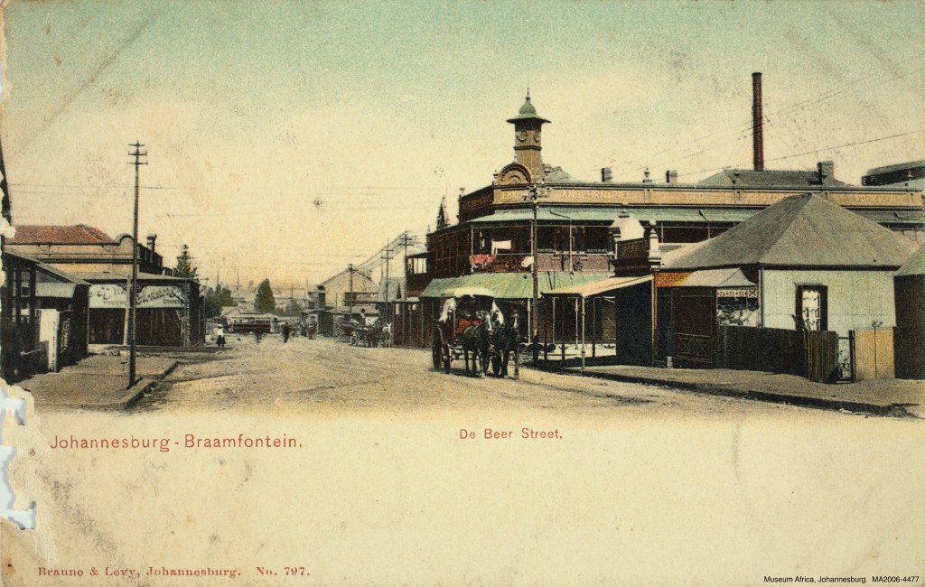
The area we know as Braamfontein today runs from the Braamfontein cemetery in the west to the Civic Centre in the east and from Wolmarans Street in the south up to Hoofd Street in the north and includes the ridge. It’s been known by this name since 1888 when the area north of Noord street was surveyed although it was never declared a township.


However, there are two almost forgotten older names associated with Braamfontein. One is ‘Clifton’ or ‘new Braamfontein’ and the other is ‘Lindique’s Portion’ or ‘old Braamfontein’.
Clifton
Clifton appears to be the part of Braamfontein north-west of the current JHB station or old Wanderers back then. It was not a separate suburb but just a popular name that the area was known by. On 12 November 1894 a meeting was held by Braamfontein ratepayers association and one of the motions was that the area known as ‘new Braamfontein’ be changed to Clifton. A much bigger area was suggested (almost all of what we know as Braamfontein now). Part of the reason for the suggested name change was the difficulty in finding addresses. Over time this name appears to have fallen away and forgotten. I came across a plan from 1933 for an addition of an organ room to a now demolished church in Steimens Street. The plan had ‘Clifton’ crossed out and replaced with ‘Johannesburg’ One of the last remnants of this name was the Clifton Methodist Church on De Korte Street (designed by G. Fleming) which was built in 1897 and demolished in 1973. The picture below was taken in Dec 1972 and the notice board on the last service displayed 1 Cor. 13:4 ‘Love suffereth long and is kind’


Before the Methodist Church was built, the area was also known as Braamfontein Enclosure and was the site of a quarry. This quarry may be the remnants of Frans and Louwrens Geldenhuis’s failed attempt at striking gold after they bought a part of Braamfontein to mine the ‘Clifton Reef’. They ended up dividing the land amongst themselves and focused on farming instead. In 1896 it was reported that the enclosure had been given to the government to erect churches and schools. The old quarries were filled up, fences erected and 390 trees were planted. A post office and a Dutch Reform Church were also built on the site. The name ‘Clifton’ existed as far down as the corner of Juta and De Beer Streets where across the road from Kitcheners there once stood the Clifton Hotel. I’ve also seen an unofficial map from 1905 where the whole of Braamfontein was labeled Clifton.

It is also worth noting that on the Tompkins ‘Plan of Johannesburg’ from 1890 Brixton, Vrededorp and Newtown were indicated as part of Braamfontein. Many street names and squares that appeared on the Tompkins plan no longer exist.
Lindeque’s Portion
On 7 January 1884, Johannes Jacobus Lindeque purchased the south-western portion of the farm Braamfontein from either Fans Van Dyk or Gert Bezhuidenhout (details are vague but it is known that various parts of the farm were dub-divided and sold many times over at escalating prices). According to Anna Smith’s ‘Johannesburg Street Names’, it was an area of 48 stands west of Diagonal Street bounded by President Street on the north and Ferreirastown on the south. Looking at an old map, this looks like the area around Brickfields or Newtown today. At the end of 1887 Lindeque’s Portion was purchased by the government to increase Johannesburg’s water supply. It is also mentioned that Lindeque’s Portion was the site of the Johannesburg country club which means that the portion of land was much bigger than 48 stands mentioned. From what I can make out, Gert Bezhuidenhout’s farmhouse was in what we know today as Auckland Park. His homestead made way for the Auckland Park Hotel (and lake) in 1890 which was a popular retreat in the early days of Johannesburg. In 1906, the hotel made way for the Johannesburg Country Club clubhouse which still stands today. It is also mentioned that a Piet or Petrus Lindeque bought the eastern part of Braamfontein from Bezhuidenhout in 1884 and built a homestead there in 1887. This may or may not be the same homestead that became the hotel, but it is known that a New Zealander named John Landau (the street ‘Landau’s Terrace’ in Richmond on the Melville border is named after him) bought Lindeque’s farm and named it Auckland Park after his hometown.
Another long-lost name associated with Braamfontein is ‘Wanderers View’. This referred to those homes on the hill directly above where the train station is today that looked onto the Wanderers sports ground. Running up and on either side of Rissik Street to where the Civic Centre is today were some magnificent houses that had views of the sport grounds and the city in the distance. One such house still stands and was for many years part of WITS hotel school which opened it’s doors in January 1969 and was originally known as the ‘Smit Street Hotel School’. Houses on Smit Street and Wolmarans Street were also often referred to as being in ‘Wanderers View’


Wanderers Sport Ground
Although not technically part of Braamfontein, I thought I would add the history of the Wanderers here as it played an important part in the suburbs history. I originally wrote this piece for JHBlive in Dec 2013.
A little known fact is that Wanderers used to be on the border of the old town and Braamfontein right next to the railway line. Town planning during those gold rush years was haphazard and short-sighted mainly because the ZAR government believed the rush would be short-lived and result in a ghost-town. As the reef proved almost never-ending, the town grew at a fast rate and many early land allocations had to be moved or relocated as the growth spread over municipal lines. Early cemeteries, hospitals and jails had to find new homes according to updated and modern town planning principles. Although the old Wanderers lasted in its original position until the late 1940s, its directors saw the future coming in the 1920s already when the railways slowly started swallowing up pieces of the club as it expanded to cope with high transport demands.

On 2 May 1888 a petition from the inhabitants of Johannesburg containing a request for a piece of land for sport and recreation was considered by the Executive Council of the ZAR. It was granted and the lease signed on 3 March 1890 with the Wanderers Club taking over a piece of ground previously known as Kruger’s Park. The site was a block of stands north of Noord Street and west of Eloff Street extension – right where the Johannesburg Railways Station is today and very close to the current Joubert Park. Note ‘Kruger Park’ on the 1890 map. This was the original position of the club. Also see how much growth took place in the six years between the maps.

As an aside: Just below to the right of Kruger Park and under Joubert Park is the Union Grounds. This is where Johannesburg’s first recorded cricket match took place in December 1886 between the Witwatersrand Pioneer Cricket Team and a team from Heidelburg. The Wanderers Cricket Club was formed in 1888. The first international match played at the Wanderers was in January 1889 against a visiting English team led by Major Warton. They beat a Johannesburg and team and the Transvaal team. The visiting side included C. Aubrey Smith who would later become a Hollywood star playing British roles. He stayed on in Johannesburg and got involved with local cricket and theatre.

It is said that the name Wanderers was chosen by its founders (at Sam Height’s Bodega Bar in Commissioner Street) because they were all wanderers themselves. As there was relatively little in the form of general recreation during those early years, the club quickly became the sporting and social centre of Johannesburg hosting Cricket, Tennis, rugby, soccer, cycling, boxing and gymnastics. Over time, other sports clubs edged in like the Ellis Park complex in the 1920s that took away tennis and rugby. Until 1915 when City Hall was built, the club also hosted music, opera and drama. Notably pianists Mark Hambourg and Paderewski performed there as well as contralto opera singer Clara Butt.

In 1895 the large grounds were used to house the Jameson Raid refugees. In the aftermath of the Braamfontein dynamite explosion in February 1896, the club was used as a temporary hospital (and again during the Anglo Boer War, WW1 and the 1918 flu epidemic). In February 1898 there was a fire and new pavilion had to be built. The grounds were also used as an assembly post for commandos and prisoners during the 1913, 1914 and 1922 industrial strikes and upheavals.


In the 1920s and 1930s, anyone who was anyone was seen on a Saturday night in evening dress or tails at the Twelve O’Clock Club housed in the gymnasium hall. In 1932 Greyhound racing was introduced and proved popular until banned in 1949. The original lease was cancelled in 1906 and the land handed over to the municipality. Bit by bit from 1925 onwards, the Wanderers land was taken over by the railways. During WW2 it was negotiated that the rest of the Wanderers would be taken over by the railways for the expansion of Johannesburg Station. After 58 years, the Wanderers stopped using the old grounds on Sunday 27 October 1946. The last major event was a soccer cup final attended by a record 40 000 people the previous month.

With foresight, the management of the club purchased some land in Illovo in 1936 and named it Kent Park after long standing Wanderers Chairman Victor Kent. The new grounds were originally only meant to cope with overflow, but would become the Wanderers new home. The Transvaal Cricket Union made the new Wanderers its home in the mid-1950s.
Piece of cricket trivia: The ‘longest six’ ever was hit by South African batsmen Jimmy Sinclair in 1902 at the old Wanderers while playing against Australia. He hit the ball onto an open truck on a passing goods train on the way to Cape Town where it was retrieved 1300km away. The ball is evidently preserved at the new Wanderers club.
Kitcheners at the Milner Park Hotel

There has always been an element of nightlife in Braamfontein. From the late 1980s to early 2000s there were venues like The Dirtbox, Wings Beat Bar, Dukes and Therapy? to name a few.

Braamfontein’s recent night life revival started around 2009 when Andrew Clements started using and hiring out the old Milner Park Hotel as a DJ venue. Charles Leonard and I started our monthly REFORM! parties on Thursday nights at the end of 2009 at Kitcheners while there were still residents living in the rooms above the bar (the parties still faithfully take place at Kitcheners every few months). The entrance had the old reception area and the SA Tourism plaque proudly announced that it was a ONE STAR establishment.


Renovations started in 2010 and the upper floor of the hotel was converted into office space. The bar next door was gutted and eventually became Great Dane which opened in 2012. The old entrance has since been transformed into another bar area but the original Carvery Bar has been left largely unchanged which lends to its charm.


Kitcheners lead the way to establishing Braamfontein as a left-of-centre clubbing and bar destination. Milner Park Hotel, or Kitcheners as its known today, is considered the second oldest bar in Johannesburg. It is certainly the oldest building left in Braamfontein and is among one of the few remaining buildings in Johannesburg built before 1900. It’s on the corner of De Beer and Juta streets which in the 1890s had a very strong German community with thriving German owned businesses (and was even known as ‘little Germany’). According to Mike Bosazza’s piece in the Johannesburg Heritage Journal, it was built in 1898 and was originally known as the Hansa Bar and Hotel. Unfortunately the plans for the hotel no longer exist making it difficult to verify. Looking at dated plans from buildings and other hotels close by, the date is plausible.

The piece below is from 101 beloved bars of Southern Africa. We now know the name ‘lost in the mists of time’ it refers to, and that it was still known as the Hansa Hotel in 1915…
“In 1899, southern Africa slipped into the cataclysmic Boer War, also known as British high commissioner Sir Alfred Milner’s ‘Little War’. At the end of the conflict in 1902, Milner had a meeting with the strong-willed commander of the British forces General Lord Kitchener of Khartoum, at a small, newly built hotel in what is now Braamfontein. This inn, whose name is lost in the mists of time, served as a watering hole for British troops and as a stopover for postal riders between Johannesburg and Pretoria. It is not clear if Milner had by then won Kitchener over, or what they discussed. What is known is that they met in the hotel’s carvery bar: an intimate room with a small, leather padded elbow-rest wooden bar, pressed-steel ceiling, smoked-glass-partioned kiosks, sash windows, heavy drapes and velvet-patterned wallpaper. Soon after, this establishment changed its name to the Milner Park Hotel, and the pub’s to Kitchener’s Carvery Bar in acknowledgment of the honour bestowed on them. Today this hotel and pub are respectively the second oldest in the city after the Booysens Hotel and the Guild Hall. Little has changed on the Milner Park or the Kitchener, which imbues them with a certain creepiness. It is probably this, or over indulgence, which has given rise to a number of ghost legends. There are cold spots in Room 2 and mysterious footsteps in Room 14. And in the pub there have been reports of the wallpaper suddenly distorting and morphing, while others claim to have seen the apparition of a high ranking, red-jacketed British officer at the bar.” From the description above, very little of the interior of the Carvery Bar has changed since those early days which is quite a rare thing in our rapidly changing times.


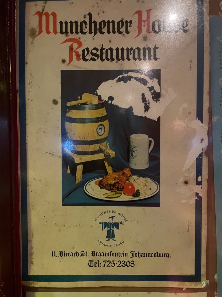
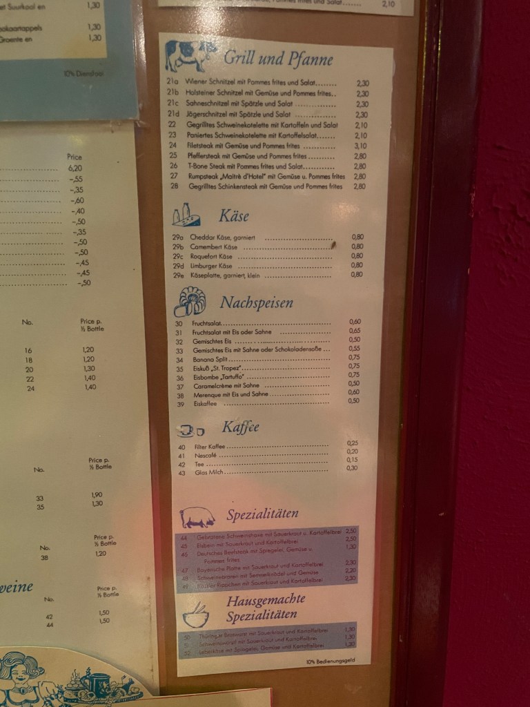
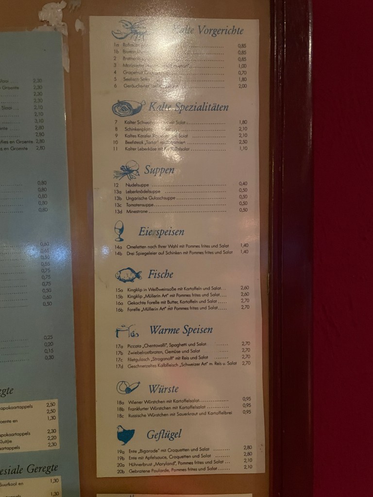
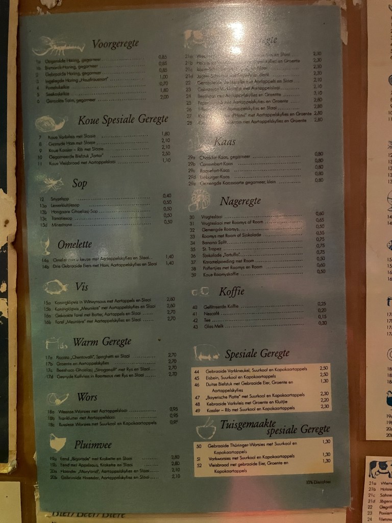
On a recent trip to Margate at St. Micheal’s-on-sea on the South Coast, I came across a branch of Munchener House. The original German restaurant was situated at 11 Biccard Street Braamfontein for many years. Intrigued, I went in to find that it was opened by one of the original owners in the 1990s. Inside was a copy of the old menu.


Upcoming parts will cover the history of Braamfontein cemetary, the dynamite explosion, WITS, Ohlosson’s Brewery, the Rand Show as well as show before and after pictures of the area where the Civic Centre now stands. I’ll also post old pictures and plans of old houses, hotels and churches that no longer exist.
Thanks to Thomas Schlotfeldt for the additional Milner Park Hotel info and the 1915 photo.
© 2014 Johannesburg 1912. Please don’t copy our content or images without permission — we work hard to research and produce everything you read here. If you’d like to share something, please link back to the original post. Thank you for respecting our work.

Leave a comment