Some housekeeping: Please follow me on Instagram at @johannesburg1912 where I post interesting Johannesburg related stuff on weekends (mainly).
Follow this blog via e-mail HERE. Scroll down on the right after archives.
My first book ‘Johannesburg Then & Now’ is available at local bookstores or internationally via Amazon or kindle. Click HERE for the relevant links
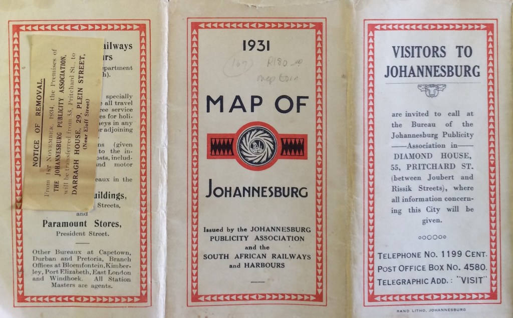
My book dealer tracked down this rare map of the Johannesburg tram system from 1931. I’ve taken a picture of the full map but as it’s quite a big fold-out map, it doesn’t photograph clearly. There are some smaller and clearer sections of the suburbs presented below as well as tram information printed on the reverse side of the map.
I’ve also added these images to the piece I did on the history of Johannesburg trams earlier on in this blog. Check out the full piece here.
The next piece ‘Braamfontein Pt.4’ and a Pt.1 of a new piece on the ‘Lost Churches of Johannesburg’ will be published around the Easter break.
Click the images for larger views.
A most interesting map of the Johannesburg tramways. Also are the descriptions of the various tram routes of nostalgic value for those who have ridden on the trams. What I very much would like to see is a map of the tram track layout at that time.
*A most interesting map of the Johannesburg tramways indeed. I am familiar with most of the routes from 1948 to the closure of the system on the 18th of March 1961. What would be extremely interesting for me would be a map of the track layout of the routes on your map.
Hoping to hear from you, Yours sincerely, Fred Craandyk.***
Johannesburg 1912 – Suburb by suburb research wrote on 21-3-2015 at 12:32: > WordPress.com > Marc Latilla posted: “My book dealer tracked down this rare map of the > Johannesburg tram system from 1931. I’ve taken a picture of the full > map but as it’s quiet a big fold-out map, it doesn’t photograph > clearly. There are some smaller and clearer sections of the suburbs > prese” >
Hi Fred,
If I ever come across the layouts, I’ll certainly post them here!
I am looking forward to those track layout maps. Fred
I have a 1929 map of joburg. Do you want to post it on your site?
Thanks Gwyneth! I’ve sent you a mail to get the file.
Yes, please do post those maps of 1929. Fred
Pingback: Thinking about public transport in Johannesburg | The New Neighbour
My life started in Johannesburg in 1939 and I have wonderful memories of those early days of travelling by tram. What excitement l. My fascination was the driver having to swing the long overhead ‘pole’ by using the long pole with a big hook on it that was kept in the ‘exhaust pipe’ under the tram. It wasn’t easy to do.
We lived in Rosettenville Ext and often took the tram to Malvern, the Zoo, Kensington, and I can remember some of the routes very well; down Jan Smuts Ave next to the Zoo fence, often seeing animals across the fence while we traveled. The track along the fenceline of Turfontein Race Course. And all prices, as you remind us, were under a shilling.
Simple living. Oh, if we could go through it again. Maybe not since we really only remember the happy thoughts and not the thoughts of traipsing through town from one tram stop to another. sometimes in the cold and rain.
Michael Metz
Thanks for sharing your memories!
One thing that interests me in your lovely story, is that part of your telling about the trolley on the tram being handled by a long stick. As far as I know, the trolley was turned around by means of a rope and not a stick. Underneath the trolleybuses a holder was fitted to store a bamboo stick used to put the trolleys on the line, or to put them back after an unfortunate dewirement or to pull the trolleys down at the end of duty. But I never knew that such a long stick or bamboo was ever used on the trams. To my knowledge, all trams had ropes attached to their trolleys in order to put the trolley on the overhead, or to turn the trolleys at the terminus or to disconnect it from the line at the end of duty. Please do correct me if I am wrong.
Aha! We live and learn…I’ve lived in Joburg since 1964 and always wondered where the Rifle Range as in Rifle Range Road was, and now I know. Looks like it was between what we now know as Xavier and Harry Streets, Robertsham.
Marc, could you post a close-up of the Uncle Charlies intersection please? I see by the way that this 1931 map compared to the 1929 one, shows the road from Uncle Charlies to Main Reef Road, and that by this time Rifle Range Road is re-aligned east/west to come out at Uncle Charlies.
Sure! I’ll e-mail it to you tonight
Tram to Westdene c1952
I’ve just done a brief walk-about of Yeoville and had many memories refreshed, dating back to the early 1950s. Explored the ‘New Library” at 51 Raleigh St., and was surprised to find an, internal, travelling-crane and gantry; the remains of what used to be part of the “old tram shed which also functioned as a city power substation…,dates 1924″ (Extract from the Library’s very sketchy history”). Alas, not much luck, yet, in “googling” further historical information in that regard. Does such exist and will someone please point me in the right direction.
Hi Gerron, It’s not something I’ve heard of. Perhaps one of the readers will have some further info for you. I’ll let you know if I come across anything. Marc