Ferreira’s Dorp or Ferreira’s Town (or both one-word variations) is an area in the south-western part of the originally laid out township of Johannesburg. It borders Marshalltown, Newtown, and Westgate.
It predates the birth of Johannesburg by several months and holds the early history of Africans, Chinese, Jewish, and Indian communities in the mining town that eventually became a city.


The Westgate in relation to Ferreira’s Dorp was established in July 1930 by the City Land Corporation and approved as a township in July 1932. It was land literally to the west of Ferreira’s Dorp, and although there was no physical gate, it was where one entered the city from the west. An article in ‘The Junior Red Cross Magazine’ from November 1949 spoke about the earliest days of Johannesburg that may have inspired the name Westgate. It spoke about entering Johannesburg from the town side of Ophirton, and that although there was nothing that resembled a gate, there was a broken down scotch cart on one side of the track, and a white tented wagon on the other near which were Col. and Mrs. Ferreira. Essentially, the road from Kimberley passed through what became Westgate and Ferreirasdorp.

Westgate today is a tiny industrial and warehousing suburb that sits between Ferreirasdorp and Fordsburg with the M1 running through it. The area just south of Westgate has been largely covered by the highway networks of the M1 and M2 and their various interchanges and was previously made up of mine land and dumps from the nearby Crown Mines and Robinson GM Co LTD before they were cleared for the highway ‘ring’ that was constructed in the late 1950s and early 1960s.
Before Ferreira’s Dorp, the area was known as Ferreira’s Camp and named after the previously mentioned Col. Ignatius Philip Ferreira.

He was born in Grahamstown on the 5th of July 1840 and was investigating reports regarding goldfields on the Crocodile River and Klipriver before he found his way to what would be Johannesburg in June 1886 (four months before it was proclaimed or even named). As a soldier of distinction having served under Sir Walter Currie from the Cape Mounted Police and later as commander of the Transvaal Mounted Rifles, he did much to maintain law and order as the unofficial leader of the mining camp in the early days of the gold discovery and before the Kruger government sent officials. At the end of August 1886, F. C. Eloff recommended that Col. Ferreira be appointed Justice of Peace on the grounds that he was respected by all. It appears that it was never made official.
Besides looking after the camp, he was also active in pegging claims and obtaining leases, especially during the early period between June & July of 1886. Sometime later he disposed of all his claims and mining interests which were amalgamated to form part of the Ferreira Gold Mining Property. He left Johannesburg sometime after and died on 13 May 1921 on his farm ‘Kraanspoort’ 35 miles west of Louis Trichardt.
The land on which the camp was established was originally the northerly part of the Boer farm Turffontein. On 14 July 1886, Col. Ferreira and J. P. Meyer leased this part of Turffontein No.198 from J. F. Bezhuidenhout Junior. On the 11 October 1887, the South African Republic bought the contract for 5000 Pounds and incorporated the area into Johannesburg. Until the 1950s, the area was known as ‘Ferreiras’ but officially became ‘Ferreirasdorp’ in 1958.

Ferreira’s Camp was one of three early camps where diggers and fortune seekers coming to Johannesburg settled. The other two were Natal Camp (near Jeppestown) and Paarls Camp or Afrikaaner Camp (where Paarlshoop is today). Read more about the camps HERE.
The early boundaries of Ferreira’s Camp camp were roughly Commissioner Street in the North and Anderson Street in the south and Alexander Street in the west and Ferreira Street in the east. To the west of Alexander Street was a stream which rose in Kazerne near Newtown. It is the same stream running through the Fordsburg dip today. More on Fordsburg HERE. The position where he established himself was near the current day Magistrates Courts and is marked by a mining vehicle just south of St. Albans Church.

The proclamation of the goldfields was read by Capt. Karl von Brandis on the 20th of September 1886 and Randjeslaagte was to become a public digging on 4th October 1886 – the date associated with Johannesburg’s birthday. This proclamation was in part due to Col. Ferreira who presented a petition to President Kruger on 26th July 1886 signed by 74 others saying payable gold has been found in Ward Klipriver and that it be declared a public goldfield. Two days later he submitted a second letter asking that Langlaagte and Turffontein also be declared public diggings.

As more people flowed into the area, the camp became something of a settlement. Various businesses started operating from tents and primitive structures made from wood and corrugated iron or wattle and daub (reeds). Many of these are considered firsts in Johannesburg. There was a chemist, butcher, general dealers, a small school, drinking establishments, a post office, and the first hotel – Edgson’s Hotel. This rapid influx of people and the establishment of Ferreira’s Camp happened between June and December 1886.


The excessive drinking that went on day and night in the camp was an issue. Licenses to sell liquor were relatively easy to get so long as the required payment was made. The Diamond Fields Advertiser stated: “For grog shops, there was no place in the world more remarkable for them than Ferreira’s Camp. To a population, living mostly in tents and grass houses, of about two or three hundred persons, there are fourteen so-called hotels. Anyone paying his license money can get a license. No board or authority has to be consulted.”
The fourteen ‘wayside hotel’ licenses were issued by the Landdrost of Heidelburg between 24 July and 27 September 1886. According to the Government Gazette No.303 from 10 November 1886, Mining Commissioner Jan Eloff issued 25 hotel licenses. In July 1886, one wattle and daub hotel was called Walker’s Hotel. Cecil John Rhodes evidently stayed in it for one night and thereafter opted to rather sleep outside in a wagon.


Ross, the manager of the soon to be first Standard Bank branch in Johannesburg wrote the following on the 27th September 1886, “It (Ferreira’s Camp) has about 400 inhabitants; there are 24 iron buildings, a considerable number of reed and one or two brick houses, the stores and canteens (two of very fair size), and two hotels one of which is of a very fair appearance and creditably conducted.”

The government decided to survey Randjeslaagte for use as a township and Josias De Villiers was told to cram as many stands as possible into the area with as many street corners, as the corner stands would fetch higher license income. This was completed on 19th October 1886 and stands went up for auction on 8 December 1886.
Most people remained in the camps while the mining town was being built. The first wave of building in Johannesburg was green or unbacked bricks covered with corrugated iron. Roofing was either thatch or corrugated iron. Some shopkeepers simply dismantled their corrugated iron structures and moved them from Ferriera’s Camp to stands in the newly proclaimed Johannesburg township.
There was unhappiness from some traders that had set-up stores in Ferreira’s Camp. They felt they were entitled to some sort of preferential treatment as ‘pioneers of trade’ in early Johannesburg as they had invested in setting up their businesses which would now have to move, at cost, to new and presumably more expensive stands with licenses. No renewals or fresh licenses for Ferreira’s Camp were being issued at the time.
Johannesburg and the camps were never meant to become permanent. The government hoped the gold rush would be short-lived and the congregated masses and structures would soon vanish. This didn’t happen and Johannesburg would grow to be one of the biggest cities in the world not near a port or harbour.
In late 1887, Ferreira’s Camp and adjacent Marshalltown were incorporated into Johannesburg and would follow a similar trajectory of growth, change, decline, and rebirth.
Firsts
The first ‘Wayside Hotel’ license was issued to M. H. Wemmer on the 24th of July 1886. This kind of license specifically for farms or non-villages was less restrictive than a hotel license (which could only be issued in villages) and allowed the wayside to serve liquor day and night. Only when Randjeslaagte was laid out and proclaimed a village, could proper hotel licenses be issued. Once Ferreira’s Camp was incorporated in Johannesburg, these wayside licenses presumably lapsed.
Standard Bank was the first bank in Johannesburg. It was opened on by the manager Mr. Ross on the 11th of October 1886 in a tent that belonged to A. E. Miles. It then moved to a thatched cottage built for W. Percy Fraser which was near the Ferreira and Worcester mines in Anderson Street on the site that became the St. Cyprian’s church which is now an offramp. In March 1887, it moved to an unknown temporary office in the newly laid out Johannesburg and two months later into a wood and iron building in President Street overlooking Market Square. By the end of 1888, the new brick building was erected next to the wood and iron one.
The first barbershop belonged to George Meredith in Ferreira’s Camp.
The first barmaid was Amanda Aquenza who worked for (and later married) a Mr. Brown in his bar in Ferreira’s Camp. Her signature is evidently on the first Standard Bank list of customers.
The first billiard table was brought in by Chas Brown for a saloon in Ferreira’s Camp.
The first boarding housekeeper was Mrs. Minaar who at the age of 61 offered her tent to prospectors while she slept in her wagon.
The first hotel in Ferreira’s Camp was opened by Arthur Ballantine Edgson. It also doubled up as a post office. Edgson also owned a wayside hotel in Muldersdrift and was among the first people to establish himself in the camp.

Although the camp was relatively crime-free, the first theft took place toward the end of 1886. Three men stole beer, brandy, candles, and knives from a wood and iron house which was formerly Edgson’s canteen used as a storeroom for Bussey’s Central Hotel. All appeared before the magistrate.
The first share transaction took place in a miner’s tent in the camp.
The first building of consequence in Ferreira’s camp was the Central Hotel. It was constructed of wood and later moved to Johannesburg proper (SW corner of Commissioner and Sauer Streets) after the proclamation where it was rebuilt from stone quarried in Doornfontein. Edgson built the Central Hotel in Commissioner Street and leased it to F. H. Bussey who was the hotel keeper of the original wooded Central Hotel.
Cafe Francais in Ferreira’s Camp was the first cafe in of any pretension on the Rand according to ‘The Burlesque 22 March 1890’. It was managed by Rosenthal & Ritson.
The first chemist was the Golden Mortar Dispensary opened by Mr Heyman in 1886 in Commissioner Street west.

The first circus (and professional) performance was given in Ferreira’s Camp by Fillis’s Circus in September 1886.
The first school was started by Mr. Duff. On 16th November 1886, it was reported in the Volkstem that a school started in Ferreira’s Camp had 21 pupils. On 3rd December it was reported that Mr. Duff opened a school with 14 pupils. It’s thought that these are the same schools.
One of the first-mentioned religious services on record was that of Bishop Blousfield of Pretoria which was held in the dining room of the Central Hotel in Ferreira’s Camp in early November 1886.
There were no formal roads in Ferreira’s Camp at the start, and except for the rough market square in the centre of the camp, all the structures were erected rather haphazardly. The exact date of the transition from camp to the surveyed area is not known, but by the end of 1886, license money was being paid to Meyer & Ferreira which suggests stands must have been laid out. 273 stands were surveyed. Of that, 213 were 50 by 50 feet and 60 were 100 by 50 feet. Sometime in 1887, the ground was transferred to the Norton Syndicate who then received the license income.
By the end of January 1887, the poor sanitary state of the camp was attracting complaints.
In a letter dated 1 September 1887, the residents of Ferreira’s Camp wrote to the president complaining that they had purchased stands and were paying license fees and were therefore excluded from doing the same in Johannesburg. They were also excluded from the advantages of the Johannesburg residents (presumably sanitation arrangements). The license money should have gone to the government but was still being paid to the owners, so they were also worried that they would lose their stands. There were also claims of being threatened by the Norton Syndicate.
The residents signed a petition and presented it to the mining commissioner asking that the government take over the township. A sum of 6000 Pounds was considered an acceptable offer. In the letter, it stated that there were 213 stands of 50 by 50 feet and 60 stands of 100 by 50 feet, or a total of 333 stands at 50 by 50 feet.
The government offered 5000 Pounds which was accepted by the owners and the Township of Ferreira’s along with the adjoining Marshall’s township was incorporated into Johannesburg on 26th November 1887.
At the time, the majority of the stands in Ferreira’s were dwellings along with some makeshift hotels and boarding houses made out of wood and iron.
There was also very little actual mining being done in the early days on account of a lack of equipment and/or capital. Most of the work was trench digging to obtain ‘indications’ of the gold that could be expected when full-scale mining started. Most of the business was done by the storekeepers, bars, and hotels.
I will try and fill in the gaps between this early period and the 1930s. It appears many of the early dwellings remained throughout but there were permanent buildings constructed during the period. Some of its early residents and businesses did move to Johannesburg proper even though Ferreira’s was now officially part of the town. Most of the business growth in Johannesburg was centered around the market square and surrounds while demand for residences came from the new suburbs in the north and east – further away from the mines, dust, and noise.
This left Ferreira’s in a vacuum. It was not a desirable place to live or set-up a business, yet it was the gateway into the town bordered by mines which were the lifeblood of the region.
A cursory analysis of Longman’s 1890 directory of Johannesburg shows few business and residential listings in Ferreira’s Camp. There are ten bars (proprietors: Belies, Goldman, Jacobs, Korg, Macpherson, Mandelstein, Pateonski, Steinsen, and Sulski are listed). 8 of these were in Commissioner Street. In addition, there are two butchers, a blacksmith (Stoffel), a hairdresser, a miner, a produce dealer (Goldberg), a speculator (Harry Cantor), a contracting firm, and Heights Hotel. Most addresses are listed as being in Commissioner Street with a few off Market Street. In comparison, there are more listings for Doornfontein, Fordsburg, and Jeppe with the overwhelming majority being in Johannesburg or Marshalltown.
The Longman’s directory (while helpful from a research point of view) only appears to have listed white businesses and professional people (except for a listing and advert for Cassim) which may account for the gaps in Ferreira’s. It’s not known if listings had to be paid for which may also increase gaps in information.

“Society has discovered discrimination as the great social weapon by which one may kill men without any bloodshed,” Hannah Arendt
In the early 1930s, it was described by Miss Spurr as, ‘…conglomeration of dilapidated wood and iron dwellings housed on either side of narrow streets, some with broken wooden verandahs, and window panes plastered with brown paper or cheap chintz to keep out the wind and rain. Built chiefly in the form of blocks, narrow alleyways lead off into courtyards where on all sides are dingy and dirty looking rooms.’ The area was still very much mixed-race according to Spurr with ‘Poor whites, Syrians, Chinese, Indians, Malays, natives, and half-castes, without prejudice as to caste or race, each with their own peculiar habits and customs…’

Johannesburg’s first slum was ‘Brickfields’, an area just west of Newtown. It was made up of poor and unskilled Afrikaaners who settled in the area and took advantage of the surrounding clay to make crude bricks for the growing town. Adjacent was the ‘Coolie Location’ which was set aside for indentured Indians from Natal who chose to stay in the country and seek their fortune in Johannesburg. Part of Brickfields land was purchased by NZAM for railway expansion into a goods yard in 1893 (completed in 1895) and residents were relocated to Vrededorp and further to Albertskroon and Albertville.
In February 1896, other parts of the Brickfield’s slum along with part of the Malay location and Vrededorp were cleared by accident. This was the accidental dynamite explosion near the Braamfontein station that destroyed 1500 homes. The survivors merely moved to other overcrowded areas in the town, thus exacerbating the slum conditions and racial intermingling.

African connection
Demand for cheap African labour by the mines fuelled an influx of Africans into Johannesburg. Many of the mineworkers were housed in compounds on mine property but other domestic workers had to find other places to live on the periphery of the town, especially if they couldn’t be housed at their work premises. After the British took over the town, African’s were subjected to even stricter laws than under the Boer government. They had to carry passes, were (still) not allowed to walk on the pavements, were not allowed to share public transport and access to liquor was still forbidden. Africans worked long and hard for low wages and had no political rights.
Indians, coloureds, and Chinese were treated much the same.
In 1902 the area around the old Brickfields was still unsanitary and previous plans to develop it were picked up by the British. The possible outbreak of bubonic plague cleared the way for the approval of the Insanitary Area Improvement Scheme. 500 more white people were moved to Waterval Farm. Coloured people were moved to the Malay Location. Africans were to be relegated to an area west of Vrededorp. Indians, who were legally allowed purchase rights to stands with 99-year leases in selected areas proved more difficult to move. Are a result, the Africans and Indians remained until 19 March 1904 when the plague did break out. On the same night, all inhabitants were evacuated and the area burnt to the ground. Two weeks later, the whole zone was surrounded with corrugated iron, saturated with paraffin, and set alight. 1600 buildings including a temple were burnt down.

All the inhabitants were moved to Klipspruit, next to the site of a proposed sewage farm, which was 16km southwest of the market square. They were housed in corrugated iron ‘tents’ which were used for Afrikaaner women and children in the British concentration camps. This Klipspruit became associated with the Pimville and is not the Klipspruit of Soweto today. It was, however, the beginning of what would later be known as the South-Western Townships or Soweto.
Legally, only Africans could be forced to stay. The Indians and coloureds who were moved to Klipspruit eventually drifted back to Johannesburg and settled mainly in the Malay location (Pageview of ‘Fietas’ between Fordsburg and Vrededorp)
The Klipspruit removal is thus the first forced removal. It would be the first of many and its location would determine the later clustering of townships that would become known as Soweto or South-Western Townships.

Spurr’s description of Ferreirastown is similar to the ‘yards’ of Doornfontein (read more about the Doornfontein yards) as well as other slum areas like Marshalltown, Bertrams, Prospect Township, City & Suburban, Denver, Vrededorp, and parts of Fordsburg. Slum clearances and forced removals from these areas would continue to dump people far outside the boundaries of the city and would continue into the 1950s (Sophiatown) and 1960s (Pageview/Fietas).


Ferreiras attracted newly arrived people on the lower spectrum of the economic ladder across many nationalities: Chinese, Syrian, Jewish, Indian, Muslim, and Africans were able to find a foothold in the golden city via Ferreira’s. Commerce centered around boarding houses as well as so-called ‘native’ trading stores and eating establishments. By the early 1930s, Ferreirastown was considered a slum. That foothold was not always able to be transferred into legal upward commerce. With slum life, came activities centering around illegal activities like prostitution and the brewing and selling of illicit alcohol. Rentals were often exorbitant and tenants couldn’t cover their expenses with their regular income, hence the need to take up some illicit trade or another over and above the sub-letting of rooms which also added to the overcrowding. Illegal brewing and selling of liquor were common. From the start of Johannesburg, selling any form of alcohol to Africans was illegal and punishable by fines and prison. The reasons given were that Africans became demented and dangerous when drunk and also that it affected their work.
Traditionally, Africans drank a low-alcohol home-brewed beer for religious ceremonies and social events. This beer, brewed by women, could take up to two weeks to mature. ‘Town beer’ had to be made quickly to avoid detection by the police. There were various concoctions like skokiaan, skomfana, isiqataviku (kill-me-quick), and chechisa (hurry-up). Isishimeyane was made from sugar cane, yeast, potatoes, and brandy with extra ingredients like pineapple skin or whiskey to make a special recipe.
Skokiaan was a popular home-brewed concoction made from fermented corn or mealies and other ingredients (like carbide, meths, or other cheap spirits). The mixture was poured into old paraffin tins or drums and buried underground to ferment and escape attention from the police. The police would conduct raids on Friday nights to hopefully suppress the weekend drinking.


Sunday was the most popular day as most domestic staff and mine workers had their day off and would, by accounts, spend the whole day drinking. One way of selling skokiaan was to fill up a bicycle tube (or tubes) and wear it around the waist under clothes. The contents were sold by all types risking jail time for one shilling per mugful. Smuggling alcohol into the mines was another art. Old jam tins and eggs sealed with lead or hollowed-out bread hiding bottles were popular as well as smuggling bottles down the compound sewerage drains.
Some woman brewers turned their houses into bars or shebeens at night. All the furniture was removed except for benches and they charged an entrance fee. In addition to the alcohol, they sold food and arranged for entertainment in the form of a band, piano player, choir, or dancers, depending on affordability. Sheebeens themselves, while promoting commerce and meeting places, also increased prostitution and drunkenness which often ended in fights and stabbings.
Beer lost its old religious and social values and became a form of escape between the gruelling work shifts and off days. At the same time, it gave the woman who brewed them some financial freedom provided they didn’t get caught.

Newly arrived and poor Eastern European Jews who settled in Ferreirastown also profited from the illicit alcohol trade, which by 1897 had brought bad press on what the press dubbed ‘the Peruvian pest’.
Poor town planning at the time was the cause of the overcrowding and slum conditions. These didn’t just affect Ferreira’s, but around the same time, also parts of Doornfontein, Prospect Township (south of Natal Camp), and Bertrams. The early mass slum clearances and the laws which would later be the basis of apartheid-era clearances (like Sophiatown) came into being in the 1920s and 1930s. For example, the 1923 Natives (Urban Areas) Act would provide the blueprint for Apartheid in the 1950s. The result of these clearances was that people were relocated to areas based on their race – notably, Africans were moved to newly created ‘townships’ like Klipspruit. The slums were demolished and land either set up for light industry, like New Doornfontein, or white housing projects, like Maurice Freeman Park in Bertrams. Other housing projects were also set up in Fordsburg (Octavia Hills) and Vrededorp (Jan Hofmeyr) to house the poor whites. Ironically, the African population was moved further away from the city and their places of work, where transport to and from work was either expensive or non-existent (and not to mention time-consuming). It was this conflict between trying to segregate races while still needing their labour ‘from dawn until sunset’ that continually caused overcrowding in various parts of Johannesburg. The combination of a lack or shortage of housing for low-income people near low-paying jobs coupled with unscrupulous landlords who look to profit from the situation promotes the formation of slums. Slums are part of every developed city in the world but were further aggravated locally by racial segregation. All these issues still plague parts of Johannesburg today.
Jewish connection
There was evidently a high enough proportion of Jews in Ferreira’s Camp for it to be colloquially known as ‘New Jerusalem’. Many well-off German and English Jews, coming from Kimberley with big business and mining experience settled in Johannesburg and Doornfontein. The early Eastern Europe Jews soon moved from the camps into the township setting up commercial, service, and trade businesses.
In the 1890s, new immigrant Jews from Eastern Europe came to Johannesburg for a better life. Most lived in Ferreirastown and adjacent Marshalltown (with a small number settling in various parts of the southern suburbs like Turffontein, Ophirton, and La Rochelle)
It’s important to note that there was a divide in the early Jewish community. The Anglo-German Jews were wealthy financiers, stockbrokers, and businessmen, while the Eastern European Jews were mostly tradesmen, artisans, and wholesalers. Their only point of contact was the various Jewish charities and organisations. Other than that, they lived, worked, and existed on opposite ends of the town.

It was this rift that led to the formation of a synagogue in Ferreirastown, separate from Johannesburg’s first synagogue in President Street (which, incidentally, had a further split) The reason for the split was the Eastern European Jews felt the service was not orthodox enough, so sought their own synagogue based on their own traditions.
A Beth Hamadresh (place of learning) was established in a house in Fox Street in 1893. It was this, the cheap rent (essentially slum conditions), and close proximity to the market square that attracted Eastern European Jews to the area and created a Jewish Quarter where Yiddish was predominantly spoken. On the whole, they were poor but orthodox and devout, but some had bad reputations for criminal activities like previously mentioned alcohol brewing, but also organised crime, prostitution, and gambling.
This quote describes what the lower end of Commissioner Street was like: “What is it that gave Commissioner Street its special character at the turn of the century? It was the cafes and penny drinkshops and Kosher restaurants through which there moved by day and night a colourful pageant made up of the denizens of the underworld and the ‘alte Afrikaners’ [Yiddish term for Jewish immigrants who had been in South Africa for a long time]. Day and night in summer and winter, these ‘alte Afrikaners’ would while away their hours playing casino, klaberjas and dominoes. Meanwhile, their wives were probably toiling away in some Lithuanian village, waiting to rejoin their men . . .”
After the Boer war, the slum conditions flourished. A new synagogue, the Adth Yisroel Orthodox Synagogue, was built (this is possibly the Chassidic Synagogue indicated on the corner of Main and Ferreira Street) to serve the increased number of Jews in the area. As the Eastern European Jews of the 1890s prospects and financial standings improved, they moved away to better suburbs like Fordsburg, Jeppe, Doornfontein, and Hillbrow, to be replaced by a new wave of poor Eastern European immigrants. The older immigrants set up their businesses and built synagogues in their new areas establishing new Jewish enclaves.
The new immigrants (sometimes known as ‘greeners’) were more socialist in their views. They settled in and around the slum areas. A major economic activity was serving the black population and mineworkers. Many of the new arrivals, who could not speak English or Afrikaans, ran or worked in poor conditions in ‘native eating-houses’ while others worked as clerks or labourers. Although looked down upon by the white population for serving Africans, they were still in a better position than the Africans on a racial hierarchy basis on account of their white skin.

“By 1913 the biggest concentration of Jews was in Ferreirastown. The worst slum area was opposite Ferreira Mine. Here was Cohen’s Yard or West Anderson Chambers, which consisted of single-storey rooms on three sides opening into a yard in the middle in which the tenants did their work.” (Quoted in Barry and Law, 1985: 28)
The first Beth Hamadrash became too small to accommodate the increased population and was eventually demolished and replaced with a larger building. It remained the centre of Jewish life in the area and was also home to Chevra Mischna U’gemara (or Brotherhood Society to Study the Oral Law). The new synagogue had a mikveh next to it for the use of the very devout
congregation who lived in the area. In 1916, a Talmud Torah was also started for the children of the congregation so that they could learn the laws and customs of the very orthodox form of Judaism practiced in Ferreirastown and Marshalltown (the building is technically in Marshalltown).

The quality of housing and accommodation continued to deteriorate in Ferreirastown to the point that it was considered one of the worst slums by 1930s. During this decade, all the remaining synagogues relocated to Doornfontein, and those Jews that were able to also moved out to various parts of the city.
The Chassidic synagogue had moved to Doornfontein in the 1920s already. All that remained were some charitable organisations, a few kosher stores, and the really poor who could not afford to move. The Beth Hamedrash still served as a centre for the community until it was finally demolished in 1947. The new Beth Hamedrash Hagadol was also built in Doornfontein in the 1930s with money from the sale of a Talmud Torah on the corner of Fox and McLaren Streets. The two Beth Hamedrash’s operated together until 1946.
The Ponevez Sick Benefit Society was established in 1896 in Ferreirastown where the synagogues served as the house of prayer, and communal meeting place for immigrants from Ponevez (Jubilee booklet from 1949 says 1899). The first building was on the corner of Becker and Fox Street opposite where Mandela’s law firm building is today. It was part of the clearance for the Magistrates Court buildings. Later, the organisation moved to Beth Hamedrash for a short time. New premises that included a nursing home were established on the corner of West and Main Streets. By 1930 the majority of its members had moved to Doornfontein and a new Ponevez Synagogue was built in Hilner Street (Saul Margo c1931) which survived up until the 1960s. The West and Main premises were eventually demolished when the 45 Main Street Anglo headquarters were built. There is evidently a brass plaque at the site commemorating the society.
Synagogue in Fox Street
The Eastern European Jews established their congregation (JOHC or Johannesburg Orthodox Hebrew Congregation) and synagogue in 1891 in a house at 42 Fox Street on the western side near Ferreirastown. This house was rented from Harry Filmer (and was also used for early Catholic services prior to the first Catholic church in Smal Street). It was known as Beth Hamedrash (House of Learning).

In 1893, the Trustees of the JOHC bought a stand in Ferrierastown with a small house on it. Plans indicate alterations were done to the house by architect A.P. Menze. A mikveh was erected behind the house. The building was finished in February 1893 and the scrolls were transferred from Filmer’s house.
In 1912 a synagogue was built on both the original and adjacent site which was designed by J.F. Kroll who was also responsible for the Osborne Chemist in Jeppestown and the Fordsburg synagogue. It appears as though the original building was demolished when the new synagogue was built. The foundation stone was laid by I.W. Schlesinger on 9 June 1912 and the synagogue was officially opened on 8 December 1912 by Gustave Imroth. It stood until around 1947 until Anglo American bought up all the land to build its new headquarters although membership dropped in the late 1920s.

Part of the Ferreirastown slum clearance made way for the magistrate’s court block which in turn attracted new buildings that replaced the old. The old synagogues made way for a modern Art Deco buildings like the Anglo American headquarters. Other parts of Ferreirastown were seemingly left as open stands which still largely remain today.

Chinese connection
The Chinese clubs were described as breaking the drabness and monotony of life in Ferreira’s. The original Chinatown was centered around the western part of Commissioner Street in the Ferreirasdorp area bounded by Commissioner, Market, Fox, Alexander, and Becker Streets. It was historically known as the Malaikam. This is where Chinese culture in Johannesburg is anchored.

Most South African Chinese (i.e. those with South African citizenship) are descendants of immigrants from China who arrived after 1870 and came from the Guandong Province of South China. They came to South Africa with the prospect of a better life in a ‘new, young country with anticipated riches and resources.’ Keep in mind that ‘free’ Chinese continued emigrating to South Africa up until the 1940s and again from Hong Kong and Taiwan in the 1970s. The complicated generational ties can go back one or two generations and sometimes even further. In 1904, there were 2457 (23 of them women) Chinese in SA and around 6000 in 1947 (1877 woman).
The 63 695 imported indentured Chinese miners, who first started arriving on the Rand on 22 June 1904 and finally left in March 1910, are not the forefathers of the Johannesburg Chinese community. They had very little impact on the local Chinese culture other than forcing some negative connotations about Chinese onto the general public.


There was much resistance to this scheme (even by the local Chinese), but labour was needed to work the mines after the war. After some negotiations, the ‘Transvaal Experiment’ proceeded but with strict and restrictive stipulations. Key was the return of all workers back to China after the contract period. Their impact on the mining industry and their presence during that difficult period needs to be highlighted. The annual monetary yield from the mines after the war and prior to the Chinese miners arriving was just over 1 Million Pounds. After 1904 it rose to 15 Million Pounds and almost 31 Million Pounds in 1909.
Unfortunately and prior to the experiment, local Chinese were included in legislation along with Indians (termed ‘Asiatics’) that curbed and controlled competing with white-owned businesses. These included other ‘Asiatic’ laws relating to citizenship, land ownership, and pass laws.
Most early Chinese immigrants became shopkeepers and traders. Some ran ‘native eating houses’ or became butchers. Others started dressmaking or tailoring businesses. A fascinating ‘trade’ brought over by the Chinese was a game called ‘fahfee’. It’s a type of superstitious lottery based on betting on numbers from dreams.
One of the key organisations was the Transvaal Chinese Association. It was the base for political activity in the early 1900s. Members took part in the passive resistance campaigns led by Gandhi and the Indian community between 1906-1911 risking jail and deportation.

In 1909, a riot broke out in Chinatown between the Chinese resistors and non-resistors, resulting in 4 injuries and 29 arrests. After this, the Chinese ‘passive resistors’ and those of the ‘party of compliance’ split. Although determined to resist discrimination, they preferred the less public and more solitary and peaceful action.
Chinese clubs included the Cantonese Club, the United Club, and the Reform Club and appear to have been frequented by the community based on political affiliations, especially the Reform Club, where the name of Generalissimo Chiang Kai-Shek was spoken with reverence (from the late 1920s onwards).


Treated as second-class citizens, the Chinese were not allowed to buy property or live in white areas. As a result, they lived around Chinatown in Ferrerasdorp and ‘Fietas’ as well as other areas inhabited by non-whites like Sophiatown and Martindale. When these slum areas were cleared in the late 1950s, the Chinese, given that they were a small community, were given permission on a permit basis to reside in certain parts of Johannesburg around the city like Mayfair and Belgravia.

South Africa’s trading relationship with Japan after exiting the Commonwealth in 1961 inadvertently helped local Chinese because Japanese immigrants were granted ‘honorary white’ status. Most people couldn’t tell the difference and the Chinese were able to gain acceptance into previously ‘whites only’ areas. By the 1970s with a new wave of immigrants from Hong Kong and Taiwan, the Chinese were now also considered ‘honorary whites’ and were able to live in white suburbs and send their children to nearby schools (not without resistance by certain sections of the white population). It must be noted that the Chinese community always saw themselves as Chinese and not ‘white’ as per the classification of the day and they resisted any official re-classification to ‘white’.
Muslim and Indian connection
Although it’s accepted that the original 1906 wood and iron Kerk Street Mosque was the first in Johannesburg, some interesting information has surfaced that points to an earlier site in Ferreirastown.
According to the book ‘Islam in South Africa’, the first mosque was established in 1888 in the Malay quarter of Ferreira’s Town and demolished in 1907 after being condemned as unsanitary. The plot of land was incorporated into the Juma Masjid Society in 1916. It’s generally accepted that the Kerk Street site was used by Muslims prior to the first solid structure being built as detailed below but I was drawn to a piece of information about a plot of land of religious value near the sheds at 1 Fox Street that is owned and preserved by the Mia family. This is the quote from http://www.skysrapercity.com by user Pule “Around the corner, in Alexander Street, lies the remains of the city’s first mosque, which has been walled off and retained as sacred ground by the Mia family”. This ties into the 1888 scenario as this area was still within Ferreira’s Town. Kerk Street is much further north and outside of the boundaries of Ferreirastown.


Liz Delmont Kindly sent me her research on this. Below are excerpts relating to the Indian community and Stand 227 in Ferreirastown:
Indians also suffered under the racial laws which resulted in segregation, economic restrictions and freedom of movement. Indians coming to Johannesburg could be differentiated into two groups: the ‘indentured’ and the ‘passenger’ Indians. Most indentured Indians were Hindus who had come out to work in the cane fields and coal mines of Natal. After their service finished, not wanting to return to an impoverished India and having become ‘defiled in terms of the caste system’ as indentured labourers (Tomaselli, 1983: 216), they stayed on in South Africa. With little capital, it was very difficult for indentured Indians to enter the trading market as under the 1885 Transvaal Law no 3 (also known as the anti-Indian law), Asians were forced to pay £25 in order to enable them to trade. This same law also prevented Indians from owning land. In 1887, with the second sale of preferential rights on stands between the 2 existing strips of Randjeslaagte (roughly between Bree and President, Diagonal and Nugget), it was decided to reserve some 81 stands in the north-west of this area for ‘Arabs’, the word used to designate Indians. (Beavon, 2004) (This became known as the Coolie location. The Gold Law of 1898 (extended in 1908 as the Precious Minerals and Base Metals Act, Law no 35 of 1908), ‘curtailed appointments on any land proclaimed for mining’ (Tomaselli, 1983: 216). This precluded all groups apart from whites from any access to controlling any production in the mining industry. The only available employment for indentured Indians in Johannesburg at the end of the 19th Century was at the lowest economic levels: ‘small traders, hawkers, labourers, market gardeners, hotel workers, and domestic servants.’ (Tomaselli, 1983: 216)
The ‘passenger’ Indians, predominantly Gujurati or Urdu speaking Moslems, came to South Africa as traders. Many ended up running very successful businesses (Tomaselli, 1983:216). Eshak and Tayob point to the complex history of the Muslim community in Johannesburg. According to Eshak the first Muslims came not from India but were Malay Muslims from the Cape. It was these Muslims who set up the first mosques. Tayob in his chapter on Transvaal mosques confirms this, elaborating on it with slightly different connotations: he notes that land restrictions did not apply to Cape Muslims and so they were used as nominees to register mosques by Transvaal Muslims. White nominees and even state officials were also used as nominees.

Official documents show that the mosque, the Jooma Masjid, was acquired by a transfer dated 5 April 1888, with the certificate of transfer duty number 3524.’ (Eshak n.d. :1)
The 1893 (20 June) title deed (lost but copied) certified on 16/02/1926 shows that the following had title granted by the Mining Commissioner Johannes Lodewicus v.d. Merwe to stand 227 as the Mohamedansche Kerk Gemeente
It appears that this was ratified in a Supreme Court decision of 6th December 1921. Pencharz and Jacobson attorneys were appointed trustee (transfer no 4193) on behalf of Church Council of the Mahomedan Church.
All went quiet for another 50 or so years until the late 1960s when another action was brought against four men claiming to represent the Mohamedan Church by Ahmed Mia to overturn the sale (on 13th February 1968) of Stand 227 to Mainway Investments Pty Ltd.
They claimed that they had, since 1936, been entrusted with the task of managing and controlling the stand. The proceeds of the sale were to go to the Juma Masgid Society. The court ruled in the favour of Ahmed Mia and the sale was prevented on the grounds that the 4 men were not members of the Church Council, that the legitimate members of the Mohamedan Congregation were not consulted and that the sale of the stand constituted the sale of holy land which is against the Islamic faith. What is of further historic significance is the high profile of the various legal teams. Acting for Desai in the initial hearing were N.G. Patel as attorney (his rooms were at Chancellor House) and Sydney Kentridge and Lochoff as advocates. Acting for Ahmed Mia were S.H. Cachalia and M.A. Loonat as attorneys and Unterhalter and Bizos as advocates.
‘It appears that with the movement of the Muslim population, the mosque disappeared mysteriously and no efforts were ever made to reconstruct the mosque on the said land. …. A group of concerned Muslims had hoped to build a mosque on stand no 227 but nothing materialised. Suddenly in the late 1960s, a group purporting to represent Islamic interests informed the local authorities of its authority over the consecrated ground of worship. They felt there was no point in building a mosque, and were busy negotiating the sale of the land for R70,000-00 to a company based in Johannesburg’.
Although there are no documented records such as photographs or plans of a mosque on the site; nor can anybody in living memory verify a mosque building on the site, the Supreme Court document stamped 26/09/1972 Case no M561/70 makes reference to a mosque on the site.
Since its purchase up to about 1930, there was a mosque on the property which was used by members of the Muslim community and regular prayers were held. Indeed, the property was a centre of religious activities of the community. However, the evaluation rolls show a building to the value of £250 on the 1905 evaluation roll but from 1910 onwards the value for the buildings is given as 0.
Furthermore in a letter dated 26 July 1954, Mr Friedman to the City Valuer on the instructions of the Mohamedan Congregation in regard to a remission of rates, confirms there is no building on the site but notes that :
‘as a mosque has already existed on this stand it is incapable, in a religious sense, of being used for any, other than religious purposes’
Garda reports that on the site [in 1988] there was a temporary green dome symbolising a ‘mihrab’ although he notes that disappointingly the site is walled off and the locked steel door denies access.
The Mia family have not responded to my requests to verify this information.
Old landmarks:
I’ve marked blocks below from A – X and tried to pull together what was originally there and what is there today. Click or save the image for a more detailed view.

A-220 Chinese Shops

A-221 Cantonese Club 1905
The first of three Chinese clubs in Ferreirasdorp, the front outer shell of the building still stands on the NW corner of Fox and Alexander Street as can be seen by comparing the photos. Building lines on the newer buildings on the left (c1940s) can still be seen from older Google Earth screenshots, but have since been plastered over. Fox Street elevation was originally longer than what is seen today.


The club was founded on 1 June 1898 and was also known as Kwong Hok Tong. It was actively involved in the 1906-1911 passive resistance campaign and hosted Gandhi as a speaker during this time. The club building was erected in 1905. Besides the usual club facilities for its roughly 150 members, Chinese travellers could also rent rooms in the club as nearby hotels would not let rooms to non-whites. The building was damaged in a fire in the late 1940s and was repaired and modernised (this may explain the shortening of the western end). The building was ‘demolished’ in the early 1980s.


The extant exterior wall window sills and window positions on the site can be lined up with the club photos above confirming that the whole building wasn’t demolished. Only the eastern ground-floor wall remains.
B-185/186 Transvaal Chinese United Club Mansions 1948
Designed by Pabst, this sculptural building was described best by Chipkin as “..curved forms and cubic projections; rounded corners alternating with sharp rectangular cantilevers. On the west elevation to Alexander Street, splayed shapes pick up northerly natural light while the elevation undulates, folds, splays, separates and re-integrates in an incredible assemblage of forms…The building…represents an endless series of improvisations derived from the imagery of 1920s Berlin.”

The building is a modern take of flats above and shops below. Examples of Chinese shops on street level is Swallows Inn and Lucky Cafe


B-183/184 TVL Chinese United Club 1909
The building dates to the late 1890s, but only started being used as the Chinese United Club in 1909.
B-187/188 Chinese connection (now vacant land)
C-148 Chinese connection (now vacant land)
D-103 Originally shops and rooms designed by Kroll 1896 Chinese connection
D-107 Chinese connection
D-109 Bakery 1896 Fox Street
The building still exists and is currently called Chambers on Fox & Heritage Cafe. Possibly the original structure dating to 1896 designed by Ibler and J. F. Beardwood (who also designed Parktown Convent and countless other buildings).

D-110 Chancellor House 1948
The building was designed by Frank Jarrett and completed in 1948 for the original owners S.H & I Bentel. Nelson Mandela and Oliver Tambo opened their law firm in 1952 in offices in Chancellor House. It was the only black law firm in South Africa at the time. After Tambo’s exile, Mandela moved the practice to Flat 13 Kholvad House a few blocks away on Commissioner Street in 1960.


E-64 Suzman Tobacco shop Cnr Commissioner and West (exact corner not confirmed)

E-65 Originally shops and offices 1897
Designed by J. B. Nicholson for owner Kanterowitz
E-66 Shops 1895 Chinese connection
Designed by C. H. Brauer for E. Goldstein
E-71 Shops and Chambers 1896 Chinese connection
Designed by C. H. Brauer for owner M. Stein. Harry Zeederberg wrote of a Chinese shopkeeper known as Ah Ling. The shop was located on one of the West and Fox Street corners. If not this one, it may have been across the road at F-7 as both are indicated to have a Chinese connection. Ah Ling is said to have been one of the few Chinese mine labourers and interpreters who remained behind from the great labour experiment. His shop stocked everything and resembled a cross between a museum and a workshop. One day in 1932, it was noticed that his shop had not opened long after it should have. The police were called and broke in to find him dead. He was held in high esteem as the mayor at the time D. F. Corlett attended his funeral. He said of Ah Ling, “He gave liberally to the various welfare funds during the depression years – far more than many other firms or individuals. Whatever his religion may have been, he dispensed Christian charity.”
F-1-3,9-12 African / Rand Hotel 1897 Fox, Ferreira, and Commissioner Streets
Plans for the Rand Hotel by new owners African Hotel Co. LTD were submitted designed by C. H. Brauer. This ambitious hotel took up stands 1 – 3 & 9 -12 of the block. There where further additions in 1902 after the war designed by Aburrow & Treeby


F-3 Height Hotel 1895 Commissioner Street
Plans for stand no.3 date back to 1895 for owners Goldberg and Harris with design by C. H. Brauer. It appears Height’s was short-lived as 2 years later, plans for the Rand Hotel by new owners African Hotel Co. LTD were submitted. See above. The photographic evidence shows a different position and design to these plans. It appears the design for the building on Stand 3 was not built, but Heights Hotel went through many changes and names over the years before finally being demolished.


F-4 Adler 1895
The first plans dating to 1895 are by C. H. Brauer (who seemed to have a monopoly on this block) for owner Adler. They were for additional rooms and outbuildings. In 1906, architect Archer W. Hoskings designed a restaurant and bar with rooms above for SAB. In 1940 further additions were done for owner Adelson by John B. Ferguson listed as tea room, shop, and storerooms.
F-7 Shops and studios 1903 Chinese connection
Part of the cottages row built for G. N. Doble. Prior to this, there are plans dating to 1896 on F-7 & 8 for storerooms and rooms for owner S. Brand.
F-5-8 Storerooms and Res 1921 & 1931
Additions in 1921 and new residential flats and rooms in 1931 for owners Adelson brothers who also owned F-4. John B. Ferguson designed the 1931 flats.
G-222 2nd Chinese School Cnr Fox and Alexander
The current building on the stand may date from the early 1900s

G-225 Chinese connection (Vacant land)
H-191 Austria Imperial Bar 1892
Started as a bar with the addition of rooms in 1892 and then became a hotel in 1896 designed by C. H. Brauer for owners Bloom & Goldberg. The 1896 hotel is listed as a new building.
H-193 Cottages 1905
Two new cottages and 10 rooms for owner Marcus Baron designed by May & Christie
H-202 Cottages 1905
Two cottages and a shop for owners Magid & Eliovson
This is view is looking south up Wolhunter (between blocks H & I). Notice the headgear of the mines in the distance. The Wesleyan Church can also be seen on the right)


Most of block H had Chinese connections. All is now vacant land.
I-153 Lieberman Tobacco Factory 1903
Designed by A. Klute, the building included a factory, house, and offices.

I-161 & 152 Cottages 1905
Row of 4 cottages for H. Steyn
The southern portion of I block had Chinese connections as well as I-155 and I-151
Blocks J, K, P & Q Magistrates Court Building 1936-1941
Magistrate’s Court buildings on Fox Street take up four city blocks and are bounded by Marshall, Ntemi Piliso (Old West Str) & Miriam Makeba Streets (Old Bezhuidenhout Str). The foundation stone was laid on 24 Sep 1936. The building was designed by John Perry & Lightfoot with a classicist design. Unlike some of the higher reinforced concrete surrounding buildings, the court buildings were built low with regular brick load-bearing walls and finished with sandstone sheets. It was completed in 1941. The building also features some important national artwork incorporated into the design by Pierneef, Le Roux Smith Le Roux, and Collin Gill. John Perry, a Cape architect, was also responsible for the Library Library buildings. Both the library and magistrates’ designs were won by Perry via design competitions.


Mandela was a feature in the building both as an attorney and accused. In 1952, twenty leaders of the Defiance Campaign including Mandela and Sisulu were arrested and charged under the Suppression of Communism Act at the court. It also saw the first appearance of the accused in the 1956 Treason Trial.
J-111 Ponevez Sick Benefit Society (1st building)
Established in 1896 in Ferreirastown as a communal meeting place for immigrants from Ponevez (Jubilee booklet from 1949 says 1899). The first building was on the corner of Becker and Fox Street opposite where Mandela’s law firm building is today. It was part of the clearance for the Magistrates Court buildings after which the organisation moved to the Beth Hamedrash for a short time. 2nd Building was at the corner of West and Main Str L-22 (see below)
J-112 & 121 Shops & rooms 1896
Shops with room above for owner S. Morris.
J-118 Chinese connection
K-76 & 75 1st Johannesburg Chinese School Kuomintang (KMT) and Chinese press
The first Chinese school was established on the corner of Fox and Becker Street in 1928. On one side of the school is a courtyard bounded by a building where the Chinese newspaper is printed. Classroom arena on the other side and meeting room for the Nationalist Party Club or You Man Tong. In the early 1930s, pupil numbers fluctuated between 50 and 80 with 4 to 6 teachers. Both English and Chinese were taught. The first school was demolished for the Magistrates Courts and the second school opened on the corner of Fox and Alexander Street around 1934 (G-222). Another house on Alexander Street was also used later (M-228). It appears the school later moved to new larger premises on Siemert Road in Doornfontein and was called the Kuo Ting School (estimate the move to have happened in the early 1950s).
The press moved to a modern building on Becker Street according to Gutsche’s book published in 1947. It talks about the press being in the basement of an indistinguishable building. It was printed by a hand press imported from China and had two Chinese compositors who set everything up by hand. The newspaper “Chiao Sheng Po” was published 3 times per week with a circulation of 1100. Besides Johannesburg, it served Chinese communities in the Belgian Congo, Reunion, Madagascar, Mauritius, and Seychelles.
K-79 and 83 Chinese connections
Blocks L & R Anglo American headquarters L 1948-50 & R 1937-39
Block L became current 45 Main Street in 1948-50 (the back of the building faces Fox Street and the front Main Street) and was designed by British firm Burnet, Tait & Lorne as “a sheer cliff of Ficksburg masonry with square window insets. This opus was Francis Lorne’s monolithic answer to New York’s glazed curtainwall slab blocks that date from this period.” The only similarities between 45 Main Street and the original 44 Main Street beside the architects, is the sandstone facing and reliefs. The buildings are very different in design (see further down for Block R details).


The impala sculpture “Impala Stampede’ by Herman Wall from 1960 was relocated to the Anglo headquarters in 2002 from Oppenheimer Gardens in Joubert street where the Standard Theatre once stood. It was re-installed by Herman’s son Michael. Several of the heads had to be recast after they were sawn off and stolen for scrap prior to the move.


Prior to Anglo’s 45 Main Street, the block had strong connections to early Jewish history in Johannesburg.
L-15 Empire Chambers 1895
Designed by P. H. Krause for owners Otto & Bloom.
L-17 Jewish School 1892 Fox Street
Harry Filmer’s house originally stood on this stand in Fox Street. Alterations for the Jewish school on stand 17 were submitted in Dec 1892 by architect A. Paul Menze.
L-18 Beth Hamedrash 1912 Fox Street
The synagogue replaced the school and the stand next door (17). Building completed 12 Oct 1912. Also known as the Fox Street Synagogue. It was designed by J. F Kroll who also designed the Jewish school in De Villiers Street and the Fordsburg synagogue, being a man who ‘knew about Jewish buildings.’


The red circle shows the Fox Street Synagogue and the yellow the 2nd Ponevez building
L-22 Ponevez Sick Benefit Society (2nd building) c1935
The new premises that included a nursing home were established on the corner of West and Main Streets around the mid-1930s. It’s not known if this was a new building for the purpose or an existing building. It would have only been in use for 10-12 years. By 1930 the majority of its members had moved to Doornfontein where a new Ponevez Synagogue was built (the original Ponevez Synagogue was in Block R and was demolished for the first Anglo American HQ in the early 1930s).
The West and Main Street premises were eventually demolished along with the Beth Hamedrash in 1947 in preparation for the 45 Main Street Anglo headquarters built between 1948-51. There is evidently a brass plaque at the site commemorating the society, but I could not find it.
M-227 Site of the first Mosque in Johannesburg
The story about this stand is further up under the Muslim section. The land cannot be sold and nothing may be built on it (other than a mosque) based on Islamic law. It’s not known if a structure was ever built. If there was it was probably of a temporary nature (wood & iron). No known photos exist to verify. The area is walled off and has been for years.
M-226 Site of third Chinese School
There are some conflicting photos of the school. The picture below had been attributed to both the first and second Chinese schools on Fox Street, but it appears to be the third on Alexander Street. The now photo clearly shows where this house stood.


M-230-231 Old cinema c1950s
The building is currently an art studio.

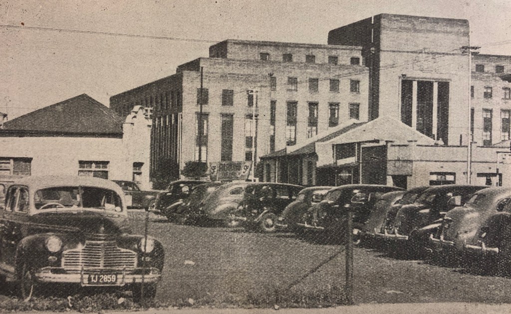
A car park now takes up the whole N block. The postcard below from the 1980s shows that the block (and others around it) were empty even back then.


N-203 & 204 Ebeneezer Congregational Church 1902 Cnr Wolhunter & Main Str
Part of a network of Ebeneezer churches run by Rev Charles Phillips. The photo is dated 1955. The church was built in 1902 and no architect was attributed.


N-205 Chinese connection
N-206 Ebeneezer Training Centre 1918
In 1918 a training centre/school was erected at stand 206 or 10 Main Street which was one stand away to the west from the church. The school also served as an early form of ‘technical school’ that taught practical skills to children of the area.


N-207 Chinese connection
N-209 Chinese connection
N-210 Shops with 10 rooms 1906 Chinese connection
Shops with 10 rooms designed by Phillip & Sinclair for owner W. Hazenburg
N-211 Billiard room 1922 Chinese connection
A billiard room, 2 cottages, and 12 rooms were designed by C. Adler for owner J. Lock in 1922
N-213 Residential rooms 1906
12 residential rooms by Phillip & Sinclair for owner W. Hazenburg.
The Zurich Insurance Company now takes up the entire O block

O-163 Justus House
This house was still on the stand in the 1980s
O-165 Bakery 1893
Bake house and oven for owner Vricker.
O-166 Cottage and additions 1896/6
A new cottage and verandah addition by P. H. Krause for owner M. Goldberg
O-167 Bar, rooms and school rooms 1896 Chinese connection
Also for M. Goldberg was a building that consisted of a bar on street level, with a residence and school rooms above. M. J. Harris is listed as the architect who appeared to have done the drawings a year later.
O-170 Chinese connection
O-172 Cottage and rooms 1905
E. H. May designed 2 cottages, 10 rooms, and outbuildings on this stand for owners Krost & Trewitsch in 1905
O-173 Cottages 1896
Two cottages were built for owner Kooper in 1896. No architect named.
Block P & Q are part of the Magistrates Courts (see Block J & K above for details)
P-126 & 134 Chinese connections
Q-88 Chinese connection
Q-94 & 95 Hotel 1896
P. H. Krause designed a hotel (not named) and shops for owners Goldberg, Cooper & Urinson on these two stands in 1896.
Block R
The entire block R is taken up by 44 Main Street, the first of two Anglo American headquarter buildings. Built between 1937-9, the deco building was inspired by the League of Nations building in Geneva. It’s only five storeys which is at odds with the deco skyscrapers that went up all over the city centre at the same time. The design by Burnet, Tait & Lorne of London (same as 45 Main Street later) the building oozes power and permanence, and interestingly, is devoid of any branding. Besides the obvious deco style, there is according to Chipkin “Fascist architecture in both the frontally abs conceptual elements…the building has not only Art Deco elements but the corrosive effect of Mussolini’s modernising classicism.” Local Maluti sandstone from Ficksburg covers the building and at the entrances are reliefs of indigenous fauna and flora.
The bronze entrance door is by Walter Gilbert, who was responsible for the gates at Buckingham Palace.


While researching this piece, Anglo announced that it would be leaving the inner city after 80 years to new premises on 144 Oxford Road in Rosebank. The fate of the two buildings is yet to be decided, but they remain under Anglo’s ownership and maintenance for now.
R-29 Chassidic or Ponevez Synagogue (c1905)
Indicated to be on the corner of Ferreira and Main. It may have been on stand L-28, but photographic evidence suggests not. It could have also been on either stand 45 or 61 across the road in Marshalltown. This synagogue moved to Doornfontiein in 1931 and became known as the Hilner Street Ponevez Synagogue designed by Saul Margo where it remained until the 1960s before being demolished for the Sivewright overpass, whereafter it moved to Harrow Road in Yeoville. The congregation moved out of Ferreirasdorp in the late 1920s already and were using temporary premises until their new synagogue was built in Doornfontein.
R-37, 38 & 39 Empress Victoria Hotel
Previously known as the Odeon Hotel, additions, and extensions dating back to 1902 by A. H & Walter Reid (of Cosmopolitan Hotel in Jeppe) for owner Davies confirm the position. The original build date of the Odeon Hotel is not known, but plans exist from 1895-7 for additional rooms and kitchen extensions which assumes it built earlier than 1895. Empress Victoria Buildings (former Empress Victoria Hotel) degraded over time and became cheap rooms for rent.


S-232 & 233 These stands (and presumably part of the surrounds) were at one-time sports grounds for the KMT Chinese school. The first Transvaal Chinese Association HQ was also situated there (listed as 2 Marshall Street) but plans also exist for a hotel, 2 shops, and 4 cottages from 1896 for owner Rosenburg designed by P. H. Krause. The sports grounds usage was likely later when the school was on Alexander Street. At some point in the 1980s or 1990s, there was a tyre warehouse on the site.
Block T is open land
U-175 Shops
This photo from 1955 shows the shops with the Avalon Theatre behind them. The row still stands today


U-177, 178, 179 & 180 Tin Town Theatre
Although no information exists on this theatre, the building looks Edwardian in design. It is currently run independently under a new and current administration.
The early history is not known, but it was known as Avalon Theatre in the 1950s. It’s also been a prayer mosque and a fishing equipment store. The Gauteng Opera Company converted it back into a theatre and used it up to 2017 before current management took over in 2019. Prior to the lockdown, the theatre hosted plays and musical recitals which will hopefully continue once the rules are relaxed. More here


V-138 Shops and ‘native eating house’ 1906 Chinese connection
Designed by Robertson for owners Davidson & Morros presumably to take advantage of the potential customer base close to the mines.
V-139 House and stables 1896/7
These were for owner A. Collings. This stand was on the very edge of the mining property.
W-136 Additional buildings 1896
Additional residential rooms were added to previous buildings on the is stand for owner E. Layman
W-100 Chinese connection
W-277 & 278 Rooms 1895
6 residential rooms were built for owners Mikolisky, Herzowitz & Sayman. Other buildings already existed on the stands.
W-96 Shops and room 1895
For owner A. Behman
In the 1930s an Art Deco building was erected on stands W-96, 97, 98 & 99. In the 1960s, it was known as Albatros House and was the headquarters for Fisons who were large-scale manufacturers of fertilizers, insecticides, and chemicals for the farming industry.


W-99 & 102 West Anderson Chambers (formerly the Ferreira Hotel)
Later named West Anderson presumably because it was at the T-Junction of West and Anderson Streets. In the 1930s, this building was a noted slum yard.
The Burmese teak bar at the Radium in Orange Grove, evidently came from the original Ferreirastown Hotel. It was noted by the same source that it was demolished to make way for the Magistrate’s Court in 1944, but this is partly incorrect. The demolition date may be right, but the building was not part of the Magistrate block. At some point, Anderson Street was extended beyond West Street and it was then that it would have been torn down. This may coincide with the upgrade of the area in the 1940s when most of the slum buildings were demolished.


Hotel La Bantu also stood on West Street but the exact location is unknown.

X-62 Shops and 3 cottages 1894
X-63 Cottage 1892
For owner JK. Nathan. Architect H. A. Goodman also designed the Freeman cottage in Braamfontein across from where Kitchener’s is today.
X-57, 58, 59 Reunert House 1952
This building was originally the headquarters for Reunert and Lenz, one of South Africa’s oldest engineering firms. The partnership started in Johannesburg in 1888 and was at one time housed within the old two-storey ‘Corner House’ in Commissioner Street. The Lenz era of the company ended in 1931 with the resignation of Otto Lenz’s son. Otto Lenz died in 1925 and Theodore Reunert in 1941. He was succeeded by his son Jack Reunert.
Reunert House was ready for occupation in 1952 and a new seven-storey wing was added in 1963.


The still-standing mansion ‘Windybrow’ on the edge of Doornfontein and Hillbrow was built by founder Dr. Theodore Reunert in 1896 (designed by William Leck) and remained his family home until the 1920s.
The company still exists today and is known as Reunert Limited with offices in Woodmead.
OFF MAP Landmarks:
Below W-102 was the Wesleyan Church Ferreirasdorp – Ntemi Piliso Street (Previously West Street and Melvill) (1927)
This was built in 1927 around the same time as the new St. Alban’s situated just behind it. The foundation stone which is still intact was laid by Sir W. Dalrymple on 6th August 1927.
There is no other information on this church except it’s sometimes referred to as the ‘Methodist church in Ferreirasdorp’ or ‘Methodist Church Westgate’. The official name from the plans is ‘Johannesburg Wesleyan Coloured Circuit Mission Hall’ and was designed by D. Macdonald Sinclair who worked on several Wesleyan churches.


The building next to the hall appears to be a hostel associated with the Wesleyan Church. The buildings are no longer linked to the church.

Roughly below where W-278, 280, and 281 and behind the Wesleyan Hall is the St. Alban’s Coloured Church, Ferreirastown (1898 and 1927)
The current building erected in 1927 designed by Baker & Fleming replaced the original wood and iron structure from 1898. The church had a largely coloured congregation. In 1958, the Anglican Diocese, under Bishop Desmond Tutu, was based at the church. In the 1960s, much of the congregation was forcefully removed from the area under the group areas act and relocated. The church was restored in 2012.


Both churches are a stone’s throw from the site of Ferreira’s tent, which, according to Google Earth, was situated where the mining truck is today. Another map also points out this spot.


Forming part of an urban renewal project in 2012, the Unit Rig Mark 36 truck took six days to transport and had to be dismantled into three in order to make its way from the Northern Cape to its current position. Following its decommissioning after 20 years of service in the Kumba Iron Ore Shishen mine, the 125-tonne haul truck was donated as a public sculpture and now forms part of the Mining Street Museum. The above three sites were on land that was once part of the Ferreira Deep mine adjacent to Ferreirasdorp.
North of Commissioner Street, on stand 250 at 14 Market St (between Wolhuter and Bezuidenhout St.) is the old Tramway Building which was a Madressa for many years. It is an Edwardian/Victorian-style double-story corner building with a gable dated 1930. However, the date on the gable probably refers to the date of a later refurbishment. Around 1985, it was used as an architect’s office by Muhammed Mayet, who later designed the new Kerk Street Mosque. The building appears to be a Madressa again.


A block east from the Tramway building are three origami-shaped steel pigeons installed in 2009 by Gerhard and Maja Marx that pay homage to the city’s longstanding Chinese community. Standing three metres tall, the sculptures form a triangle in Pigeon Square. With perching rods attached to the sculpture, the artworks serve the dual purpose of a landmark and refuge for pigeons.

This is a 1930s view down Wolhunter Street looking north towards Newtown and all the municipal service buildings at the time.

One block south of Tramway Building on stand 247 stands the current TCA headquarters in Commissioner Street. The Transvaal Chinese Association was founded in 1903 and led the Chinese passive resistance movement being the major representative body at the time. The original TCA building was at 2 Marshall Street along with the KMT school sports grounds. The chairman, Leung Quinn invited Gandhi to speak at the funeral of Chow Kwai For, who committed suicide ‘for conscience sake’ after registering himself during the resistance. He was unaware at the plans at the time. He is buried in the Chinese section of the Braamfontein cemetery.


JHB Central police station opened in 1968 (designed by Harris, Fels, Sacks, Jankes, and Nussbaum) was once known as John Vorster Square, the notorious building of the Apartheid regime where interrogations, torturing, and detention was the order of the day. The site was previously a framing factory according to the history of the Lebanese Church. The then modern police station replaced the old Marshall Square Police Station which is often mentioned in relation to Ferreirastown but was technically in Marshalltown.


Across the road is a row of old miner’s cottages which are unfortunately deteriorating at a rapid rate. No definitive building dates have been found, but they may pre-1900. In the Lebanese Maronite church history text, there is a reference to miners’ cottages in Westgate. These are likely typical examples of the various speculative housing dotted around Ferreira’s Town in the late 1890s.


Further west on the Marshalltown border on the corners of Ferreira, Fox, and Commissioner Streets on stands 1 and 10 stood the original Globe Theatre & First Empire Theatres.


Globe Theatre was built and opened on 24 June 1889 but this brick structure was destroyed in a fire on 7 September 1889 after three seasons. It reopened in June 1892 as The Globe but degenerated into a second-rate music hall and eventually closed. In 1894 it re-opened as Empire Palace of Varieties on the 1st December 1894 and its bar became an informal stock exchange. It appears to have burnt down again in 1903. It is noted that on 11 September 1906, a historic meeting was held at the Empire (or what it had become after the fire – as the 2nd Empire was built on the corner of Kruis and Commissioner in the same year). More than 3000 people which included a Chinese delegation rejected the Transvaal Asiatic Law Amendment Ordinance that required Asians of 8 years and older to carry passes as well as generally restricting Asian rights and immigration.
Across the road on the corner of Fox and Ferreira Streets on stand 37 stood Gandhi Hall. Although technically in Marshalltown on Ferreirastown border it played an important part in the area. It was built in 1940 by the Transvaal Hindu Seva Samaj and designed by Hermann Kallenbach who completed the plans in 1939. Although built many years after Gandhi left Johannesburg, the building served as an auditorium which was near the city centre that was open to racially integrated audiences. It was used by the ANC and other organisations. The area was declared white under NP rule and the property was eventually sold in the 1980s and a new hall built in Lenasia with the proceeds.


A modern building called Protea house replaced Gandhi Hall. A brass plaque long removed read: Gandhi Hall. This property was built on the stands on which the Transvaal Hindu Seva Samaj built a hall in 1939 and named it Gandhi Hall to honour the great Indian leader Mahatma Gandhi (1896-1948) who developed and evolved during his stay in South Africa (1893-1914) the principles of Satyagraha.
An Excerpt from Insurgent Diplomat by Aziz Pahad:
“I was born on Christmas day 1940, the third of five sons. My brothers were Ismail, Essop, Nassim and Juned, and our early years were spent in the small town of Schweizer-Reneke, in what was then the Western Transvaal and is now part of the North West Province. My father first worked in the family business, but later opened his own small general dealership. In 1945 my family decided, for economic and political reasons, to move to Johannesburg. We moved to a two-bedroom flat in No. 11 Orient House, Becker Street, in Ferreirastown. One bedroom was used by my parents, while Essop, Nassim, Juned and I shared the other. There was a dining room and a living room, which at night doubled as a bedroom for my eldest brother, Ismail. Friends would often stay over and somehow we ingeniously managed to create more sleeping space.


The move to Becker Street was fortuitous but fateful, since it had a profound impact on my political development; Ferreirastown turned out to be a hive of political activity. Rather importantly in this regard, Orient House was flanked by the offices of the ANC and the Transvaal Indian Congress (TIC). The Tambo-Mandela law offices were in Chancellor House, on the corner of Becker and Fox streets, and thus close to where we lived. Then there was Kosi Café, which was directly below the Tambo-Mandela offices in Chancellor House. In the absence of any public recreational facilities, Kosi Café became our regular gathering space. We also took advantage of the billiard room across the way from the café where many of the top gangsters of the area used to hang out. I knew those gangsters well and under their protection’ felt safe and secure from other competing gangs in the area. These connections led me to join the ‘Becker Street Gang’ and we earned a healthy respect from the community.
Another interesting feature of our neighbourhood was the Johannesburg Magistrate’s Court, which was also in Becker Street. Not only was this court the scene of many of the political trials, but in the absence of sporting facilities we used to play football on the lawns of the courthouse where we were constantly harassed by the police and, if caught, even beaten up. Given the strategic location of our flat, it became a hub of political and social gatherings. Senior ANC leaders, as well as those from the Indian Congress, the Congress of Democrats and the Coloured People’s Congress (CPC), all of which became stalwarts of the liberation struggle, frequently visited for lunch, supper or meetings. They included Nelson Mandela, Walter Sisulu, Oliver Tambo, Robert Resha, Duma Nokwe, JB Marks, Moses Kotane, Alfred Nzo, Thomas Nkobi, Mendi Msimang, Yusuf Dadoo, the brothers Molvi and Yusuf Cachalia, Zainab Asvat, Ama and her husband TN Naidoo, Jasmat Nanabhai and others.

It was rather ironic that the luxurious headquarters of all the major institutions representing white capital and finance were also located in our neighbourhood. Even today the massive Anglo American corporate buildings continue to dominate the landscape. I recall vividly how many of our leaders pointed to these buildings to explain the inequality of the apartheid system and the extent to which big capital complied with it, offering early exposure to the complex tensions between exploitative capitalism and the promise of socialism. This area also housed one of the main ‘pass office’ buildings in Market Street. The ‘pass’ was emblematic of the dehumanisation of African men and women, and I grew up witnessing daily the humiliation and ill-treatment of hundreds of Africans as they queued for hours outside the pass office. The Marshall Square Police Station was another landmark where many political detainees were imprisoned. In later years the notorious John Vorster Square Police Station was built on Goch Street, two blocks away from Becker Street. We had many fights with young white policemen, especially on Friday nights, when they returned to Vorster Square after drinking sprees in town. If the fights were serious, we had to stay off the streets because they were sure to return with reinforcements. Fortunately, they were often too drunk to identify anyone.”
I leaned heavily on Margot Rubin’s work on Jewish history and movement in Johannesburg which provided much information of Ferreirastown between 1900 and 1930.
Liz Delmont kindly sent me research she had done on early Indian and Muslim communities that included information on the site of the first mosque. Liz runs the Liz at Lancaster guest house in Craighall Park which is a popular destination for international visitors. Visit her blog HERE
© 2020 Johannesburg 1912. Please don’t copy our content or images without permission — we work hard to research and produce everything you read here. If you’d like to share something, please link back to the original post. Thank you for respecting our work.
Reference:
Smith, A, 1971. Johannesburg Street Names. Johannesburg: Juta & Company, LTD
Smith, A, 1976. Johannesburg Firsts. Johannesburg: African Museum (Collected by A. Smith and unpublished)
Gray, J & Gray, E, 1937. Payable Gold. Johannesburg: Central News Agency, Limited.
Rubin, M. 2004. The Jewish Community of Johannesburg, 1886-1939: Landscapes of Reality and Imagination. Thesis for Faculty of Humanities University of Pretoria
Beavon, K, 2004. Johannesburg: The Making and Shaping of a City. University of South Africa Press. Pretoria
Van Der Waal, G-M, 1986. From mining camp to metropolis. The buildings of Johannesburg 1886-1940. Pretoria: Chris Van Rensburg Publications
Callinicos, L. 1987. Working Life 1886-1940. Ravan Press. Johannesburg
Meiring, H, 1985. Early Johannesburg. Cape Town: Human & Rousseau
Itzkin, E, 2000. Gandhi’s Johannesburg. Witwatersrand University Press. Johannesburg
Macmillan, A, c1932. The Golden City.London: W. H. & L. Collingridge LTD.
Yoon Jung Park. A Matter of Honour: Being Chinese in South Africa.
Konig, J, 1950. Seven Builders of Johannesburg. J. L. Van Shaik LTD Pretoria
Anshan, Li. First Chinese and Indians in South Africa. Sephis E-magazine. Vol.1 No.2 December 2004. https://ziladoc.com/download/contents-122_pdf [Accessed 22 March 2020]
Norwich, R. 2013. Johannesburg’s Beth Mamedrash Hagodol and it’s legacy. Jewish Affairs Rosh Hashanah 2013 edition
Anthony, D. H. 2006. Max Yergan: Race Man, Internationalist, Cold Warrior. NYU Press
Zeederburg, H. Golden Days. Van Riebeek Publishers. Johannesburg.
China Town Precinct Plan 2009 – Savage & Dodd Architects for JDA
Websites:
http://penguin.bookslive.co.za/blog/2014/11/12/the-formative-years-of-a-trusted-politician-an-excerpt-from-insurgent-diplomat-by-aziz-pahad/ [Accessed 19 March 2020]
https://www.joburg.org.za/play_/Pages/Play%20in%20Joburg/Out%20and%20about/Links/Eating%20Out/links/The-Radium-Beer-Hall.aspx [Accessed 19 March 2020]
https://en.wikipedia.org/wiki/Kerk_Street_Mosque [Accessed 20 March 2020]
http://www.theheritageportal.co.za/article/vision-chinatown-remarkable-mr-walter-pon
[Accessed 26 April 2020]
https://www.jewishgen.org/Safrica/ponevez/index.htm [Accessed 15 August 2020]
https://portelizabethtimes.blogspot.com/2012/06/ [Accessed 15 August 2020]
https://mafiadoc.com/1913-satyagraha-passive-resistance-and-its-legacy_5a0933e01723dd099eb5f9c9.html [Accessed 29 August 2020]
https://10and5.com/2017/09/07/street-view-take-a-tour-of-11-of-joburgs-most-iconic-public-artwork/ [Accessed 19 September 2020]
https://www.businesslive.co.za/fm/life/2020-05-21-architecture-what-anglos-exit-means-for-joburg-cbd/ [Accessed 21 September 202]

Leave a comment